February 18, 2020, by lzzeb
Motoring maps
A blog by David Beckingham
The School map collection is primarily organised by country, with drawers then differentiated according to scale and only comparatively rarely by distinctive category. However particular types of map can be found right across the collection, and there are occasional groupings of specialist maps. The collection contains many different travel and tourist maps, for example, of which motoring maps are a particularly distinctive category.
Many of the comparatively early maps in the collection are sponsored by motoring organisations. These include the Royal Automobile Club Touring Department’s Bartholomew’s two miles to an inch road maps, dissected, mounted and folded. Many of these earlier maps in our collection carry the name of K.C. Edwards. This hints at their use in fieldwork, which might also explain the presence of large numbers of Italian and French touring and motoring maps across the collection.
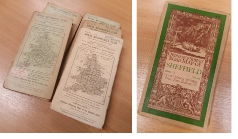
Figure 1, Left, selection of K.C. Edwards’s Royal Automobile Club Bartholomew’s Road Maps, c. 1920s (cupboard 10b); right, Ordnance Survey Road Map of Sheffield, c. 1924 (cupboard 11b). Please click to enlarge.
The iconography of the covers is fascinating. Sometimes the map covers are plain and workaday, little more than a dust cover. Others, like the Ordnance Survey covers of the 1920s, designed by Ellis Martin as the OS sought to reach a new popular motoring and walking audience, are at once modern and bucolic, conveying a geographical imagination promoting mobility and adventure in English landscape.
Two items stand out here. The first was published by the Institut Cartographie de Paris around 1925. The map, which can be viewed in detail online [1], is of the Briancon-Grenoble section of the Route des Alpes, a multi-day drive or cycle journey. It was partnered with a relief profile that shows the relative heights of the mountain passes and peaks, topping out at 2058m on the Col du Lautaret. The cover (see Figure 2) shows the towering mountain of La Meije, and its glacier swathed in snowy white. It can be seen on the right hand side of this selection of French motoring maps.
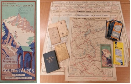
Figure 2, Left, Services Automobiles de la Route des Alpes, 3e Etape, Briancon-Grenoble (1925); right, selection including Carte Routiere series, published in Paris by A. Taride, as well as Michelin maps of various ages and a Bartholomew’s set of touring maps (drawer A60 and cupboard 10b). Please click to enlarge.
The second highlight is a boxed set of Danish Automobile Club maps, with cartography by the Danish Geodetic Institute, published around 1935. The 1:320,000 scale maps have a wonderful colour cover image of a car at a rural junction. The use of the junction and road signs, similar to the Ordnance Survey Road Map cover shown in Figure 1, of course underscores the importance of being able to plan which direction to turn. However it is the scenery that stands out so vividly, and not only because the box has protected these maps so well. As with the OS maps, regional and national landscape iconography helps to frame and sell the map by encouraging motoring. See Figure 3.
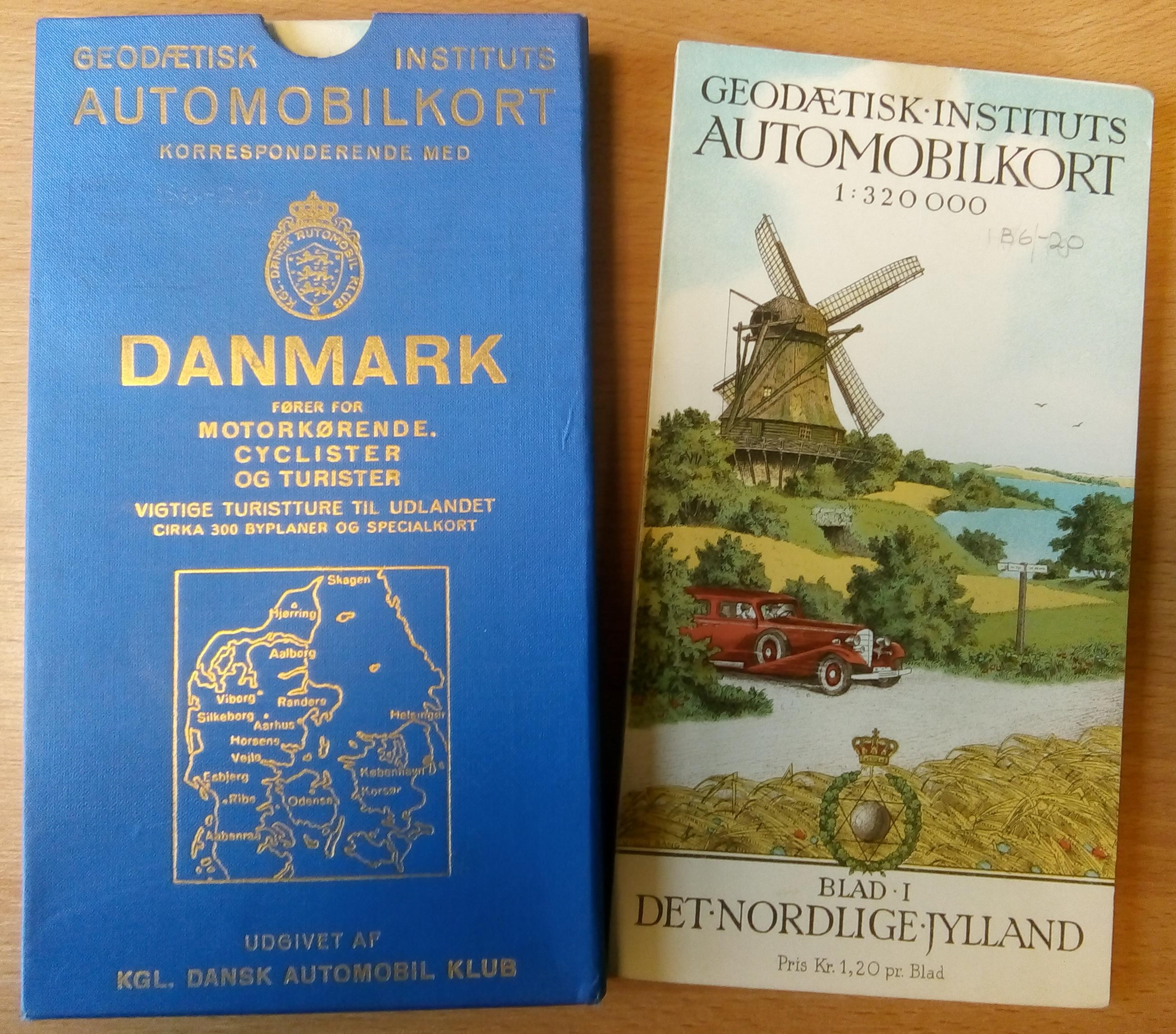
Figure 3, Geodætisk Instituts Automobilkort Danmark, 1: 320,000 (drawer A26). Please click to enlarge.
More famously Michelin had for many years been producing maps of France since around 1900 [2]. The collection contains items from different editions, some in a box of older French maps and others distributed throughout the France drawers.
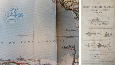
Figure 4, Selection of Michelin maps, c. 1920 (cupboard 10b). Bibendum is swimming in the Bay of Mont St Michel, from Carte Michelin de la France, No. 9, St. Brieuc – St. Lô. Please click to enlarge.
Of course Michelin was in the business of promoting motoring. The map details in Figure 4 date from around 1920. Bibendum, the Michelin Man, can be spotted swimming off the coast of Mont St Michel on a 1:200,000 map – a playful take on the beasts of the deep that occupy the oceanic margins of so many mediaeval maps. The back cover of an accompanying map in the 48-sheet series carries an advertisement for a Michelin illustrated guide to the battlefields of the Great War – Bibendum, now wearing a helmet, directing the visitors’ gaze across a barbed-wire landscape.
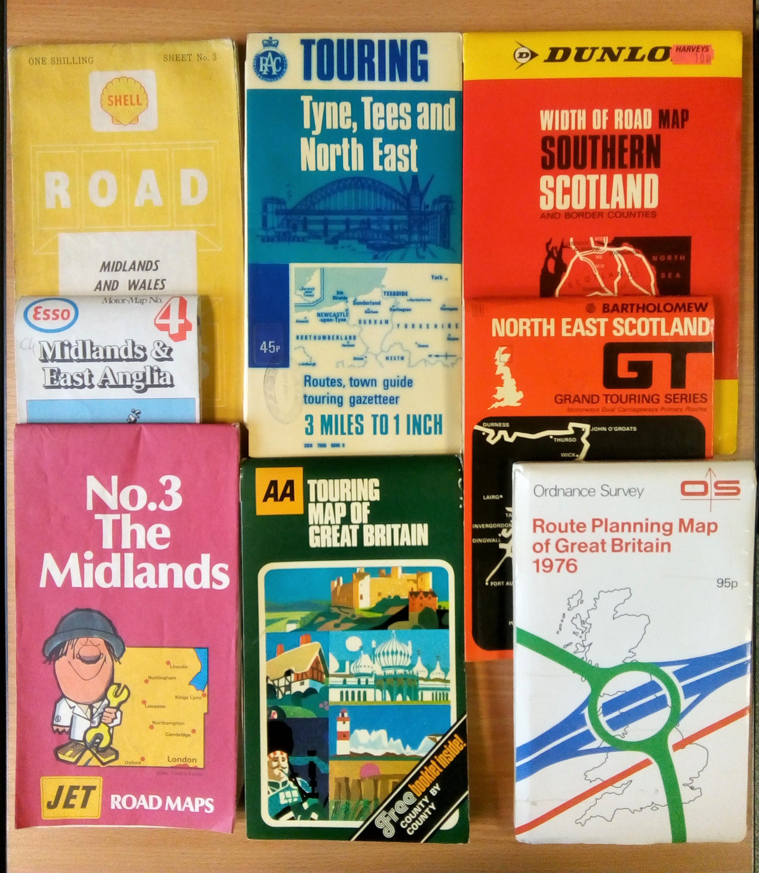
The UK maps in the collection indicate that as motoring became more accessible, and the motorway network expanded, so the sponsors of maps diversified (see Figure 5). Alongside traditional map makers such as Ordnance Survey and Bartholomew, and organisations such as the RAC and AA, the collection also contains maps that the fuel companies Shell, Esso and Jet produced in collaboration with George Philip and Son.
Figure 5, Selection of UK motoring maps (cupboard 10b)
Perhaps keen to compete with Michelin, Dunlop tyres published with Geographia a ‘Width of Road’ series to enable motorists to plan which types of roads they would like to use on their journeys. The Ordnance Survey’s word choice for its titles also makes it clear that road maps were not for drivers to consult when at the wheel. Alongside planning, however, the maps could be used by passengers – though with what success is not recorded.
As well as offering an insight into the ways in which motoring has been promoted through maps, these sheets provide a useful example of a thematic way to navigate our collection. The lack of a comprehensive catalogue for many of our drawers is certainly a challenge in such research. Yet even this small sample conveys the value of sampling across the collection to reveal the variety of the common and unusual maps it contains. These motoring examples also offer a particularly good way to think about how maps not only enabled mobility but themselves also travelled – on fieldwork, on a rare drive to the coast or the mountains, on an everyday trip to the shops, and ultimately to the drawers and cupboards of the Edwards Resource Centre.
[1] Paris Bibliothèques, https://bibliotheques-specialisees.paris.fr/ark:/73873/pf0001954445,
[2] The Michelin Archive, Stoke-on-Trent City Archives, http://archives.michelin.co.uk/in-depth/maps-and-guides/
No comments yet, fill out a comment to be the first
Leave a Reply