February 13, 2024, by lzzre
Lauge Koch and the Colonial Mapping of Northern Greenland
A blog by Dr Peter Martin
Like nearly all substantial map collections, the School of Geography holds a range of maps that depict and represent colonial and postcolonial spaces around the world. Of relevance to my own research interests, this includes a number of maps centred on those areas of the Arctic that have historically come under colonial rule.
Contained in the drawer labelled ‘Greenland,’ one of these maps in particular begs closer inspection. The Map of North Greenland, shown below, was produced by the Geodetic Institute of Denmark in 1932 and is in fact a series of maps which depict the Northern coastline of the island (known to Inuit today as Kalaallit Nunaat) stretching from Avanersuaq to Danmarkfjorden.
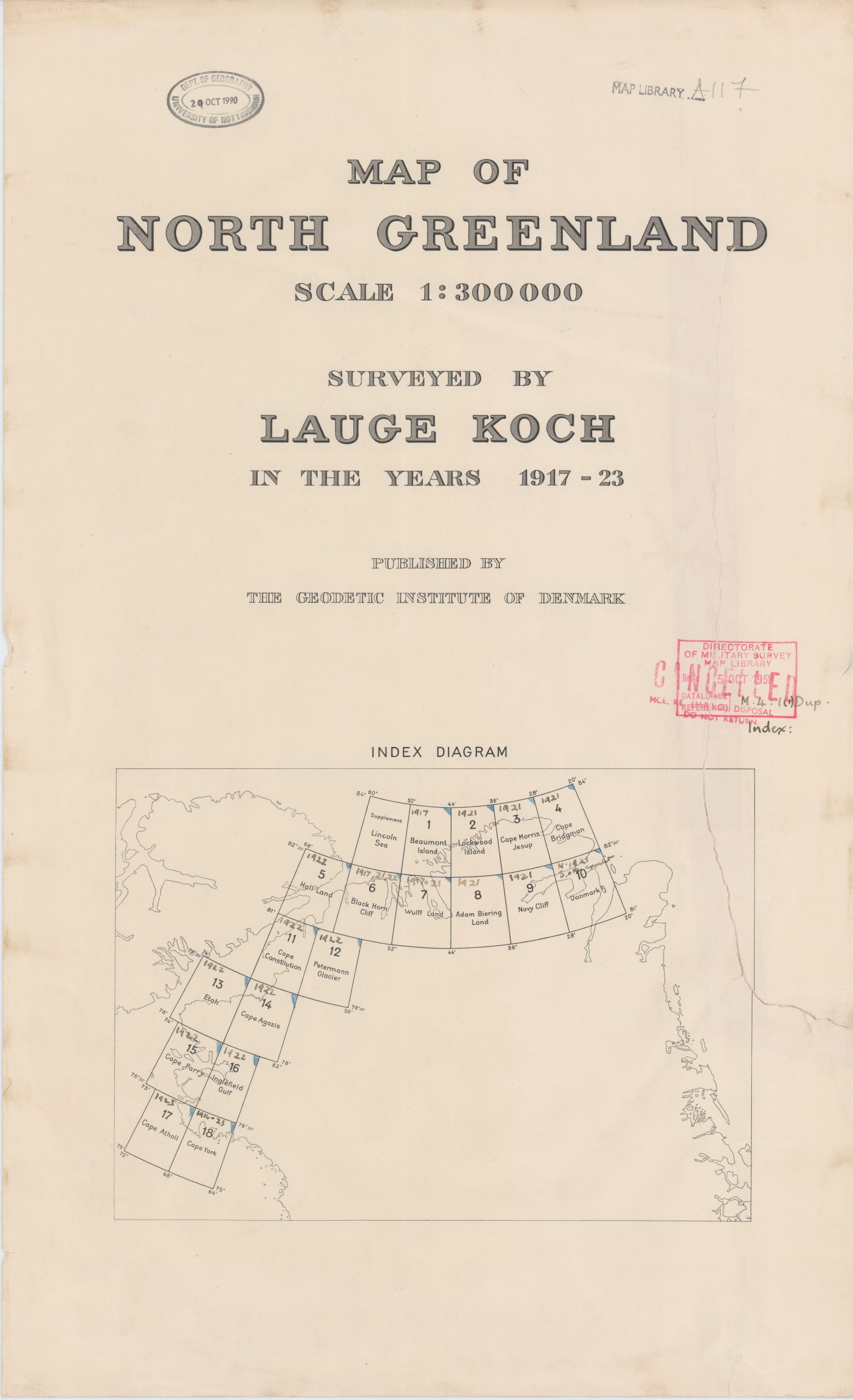
Figure 1: Cover page of Map of Northern Greenland (1932). Click to enlarge.
The cover page (Figure 1) gives an overview of the various sections of the Greenland coastline that are included in the series and also reveals that the map was produced using geographical and geological data that had been gathered by a Danish individual named Lauge Koch. Koch was a celebrated geologist and was one of a number of Danish scholars and scientists who spent prolonged periods of time travelling across Greenland in order to conduct surveys and analyses of this intemperate Arctic environment during the late nineteenth and early twentieth centuries.
Indeed, most of the data for Map of North Greenland was gathered during Koch’s largest expedition, known as ‘The Danish Bicentenary Expedition to North Greenland.’ This expedition took place from 1921 to 1923 and gathered a wide range of information about the geology and geomorphology of the island’s ice-covered Northern coastline. As Figure 2 shows, much of this information has in turn been depicted visually on the map, with blue shading used to represent ice covered areas, and brown shading used to outline the extent of the small islands scattered along the coast. The route taken by the Bicentenary Expedition has also been traced in red.
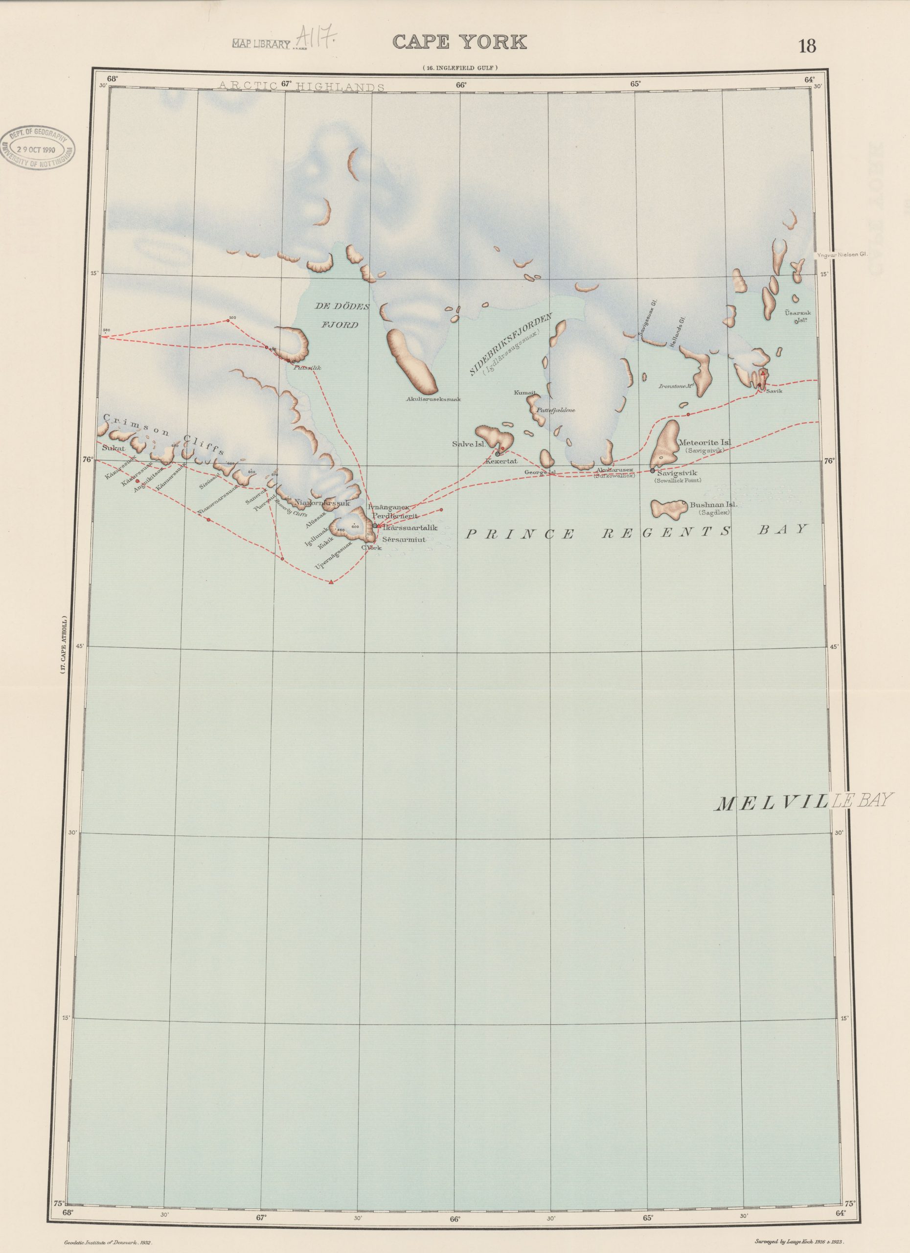
Figure 2: Map labelled ‘Cape York’ displaying route of the ‘Danish Bicentenary Expedition to North Greenland’ and the geoscientific information collected. Click to englarge.
Today, Koch is not particularly well known beyond his native Denmark. However, during his lifetime, this experienced Arctic scientist was widely celebrated for his work in Greenland, and he received medals and honours from various institutions around the world – including from Britain’s Royal Geographical Society. His ability to conduct rigorous geological investigation, and combine this with the ‘heroic’ and masculine qualities typically associated with Arctic exploration, earned him the respect of both his learned colleagues and the ‘rugged’ Arctic exploration community alike.
Yet, the Map of North Greenland also provides us with an opportunity to reflect on Koch’s scientific contributions more broadly, and to think critically about the wider intellectual contexts in which this survey work was being carried out. Indeed, the name that Koch gave to his expedition, and the ‘Bicentenary’ that it celebrated, gives us some indication as to the more problematic dimensions of Koch’s research, and indeed wider Danish scientific practices taking place in Greenland at the time.
The particular event that Koch’s ‘Bicentenary Expedition’ was commemorating was in fact the first arrival in Greenland of the Danish Missionary Hans Egede. Egede is now a highly controversial figure in the history Danish-Greenlandic relations. He was one of the earliest colonial settlers on the island and was one of the first Europeans to enact profound interventions into the lives of its indigenous Inuit inhabitants. As part of his religious missionary activities, Egede sought to convert the indigenous population to Christianity and in the process prohibited many of their cultural practices and beliefs.
Egede has therefore come to signify the troubling history of Danish colonial rule in Greenland, and has been a focal point for recent tensions surrounding it’s ongoing legacies. For example, a statue commemorating Egede, situated in Greenland’s capital Nuuk, was recently defaced, with the word ‘decolonise’ spray-painted across its base. Although a subsequent referendum in Nuuk voted to retain the statue, any commemoration of Egede continues to evoke a considerable degree of political tension in both Greenland and beyond.
The ‘Danish Bicentenary Expedition’, and the Map of North Greenland that was produced as a result, are therefore important reminders of the inextricable connection between Arctic geographical science and Danish colonial rule during this period. While Koch’s expeditions in Northern Greenland were certainly scientific in nature, and generated the substantial amounts of geographical data presented on the map, it is important to recognise that this work was funded and supported by the Danish colonial state. Furthermore, the information gathered during his expeditions was in turn used to inform and sustain Danish colonial rule in the region. Recording the locations of Inuit settlements and carefully surveying the coastline and ice conditions to facilitate travel in the area, Koch’s survey work aided the Danish government in its colonial governance of the local Inuit population. The maps extensive use of non-indigenous placenames (such as ‘Thule’, ‘Steensby Land’, ‘Olrik Fjord’ shown in Figure 3) also reinforces this sense of colonial territorial (dis)possession. Koch added the following note to a report describing the Bicentenary expedition that in many ways encapsulates these colonial sentiments: ‘On May 21 I was able to fly the colours of my country from the cairn … and thus the Dannebrog [Danish flag] had now flown along all the coasts of Greenland.’[1]
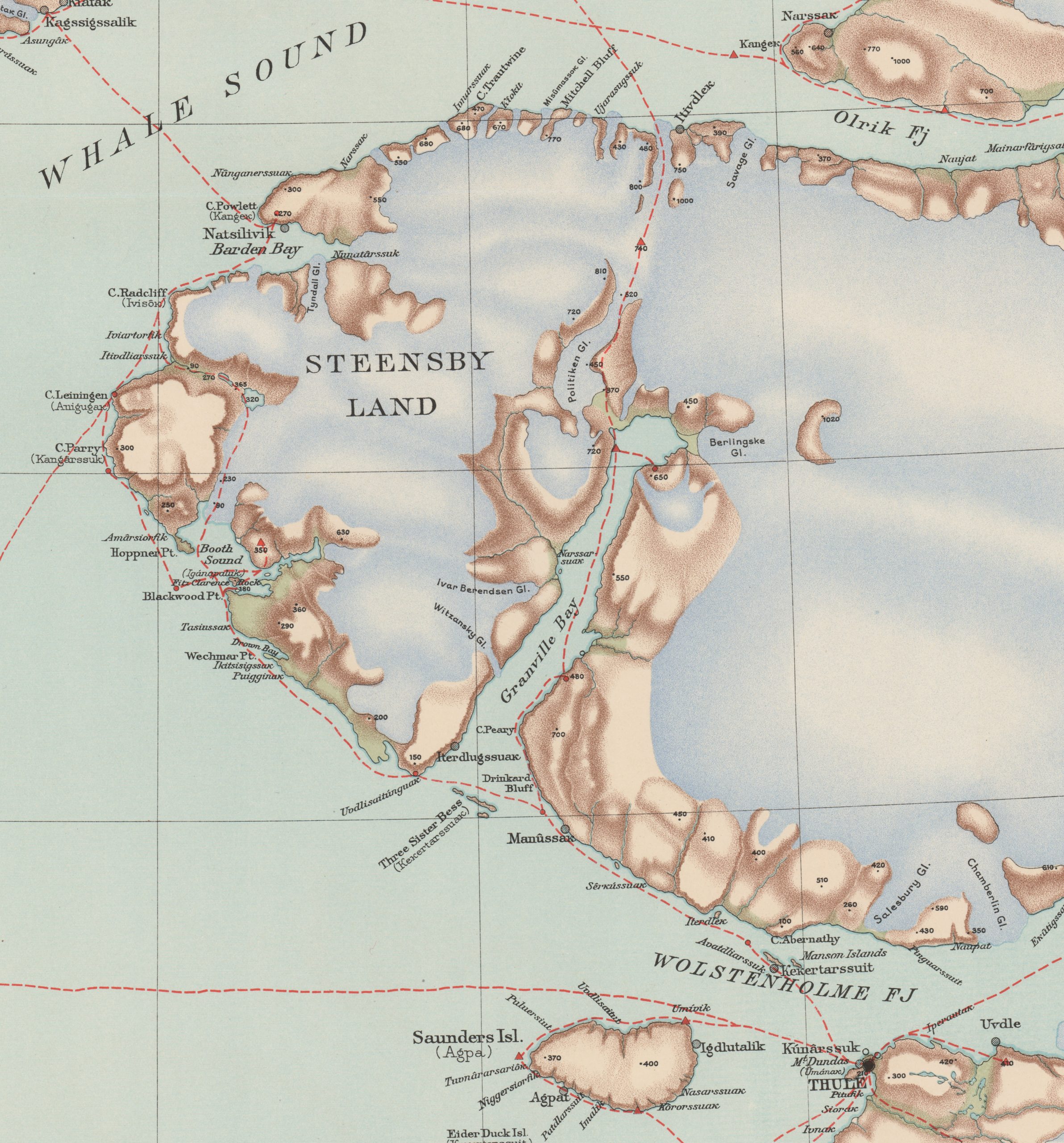
Figure 3: Extract from map labelled ‘Cape Parry.’ Click to enlarge.
Geoscience has therefore had a profoundly troubling history in the Arctic, and the maps contained in the School’s collections are the tangible remnants of these problematic pasts. It is therefore vitally important to be aware of these pervasive colonial connections when engaging with any map collection, and be mindful of the ongoing injustices faced by indigenous peoples around the world that have resulted from such historical episodes of geoscientific activity.
[1] Koch, L. (1923) ‘Preliminary Report on the Results of the Danish Bicentenary Expedition to North Greenland, The Geographical Journal, 62(2), pp. 103-117.
No comments yet, fill out a comment to be the first
Leave a Reply