August 2, 2022, by lzzeb
Last Orders: Pubs and maps
A blog by Dr David Beckingham
I am the co-curator of an exhibition called Last Orders: Stories of Alcohol and Abstinence in the East Midlands, on display at the Weston Gallery at Lakeside Arts until October.
The exhibition examines a series of tensions that gathered around drink in the two centuries before the First World War. It promotes the collections held by Manuscripts and Special Collections on King’s Meadow Campus, which have provided me with an excellent opportunity to develop a local focus to my research into the regulation of alcohol.
In my work with the records held at Manuscripts and Special Collections, I regularly came across the names of old pubs whose exact locations I did not know. I was able to use a range of Ordnance Survey maps in the School of Geography Map Collection to provide background information about the changing licensed landscape of Nottingham.
Today’s Outdoor Leisure series mark pubs with an old-fashioned tankard. On the maps in the collection, premises are much more likely to have been labelled as either PH (public house), BH (beer house) or Inn. Although they are seldom named, I was able to combine the map information with details from trade directories to locate specific pubs.
I used these details to prepare a touch-screen computer presentation in the gallery. Users can click on numbered discs – overlaying a section from Salmon’s map of Nottingham – and read stories from over 20 pubs in the town centre.[1]
Please click to enlarge
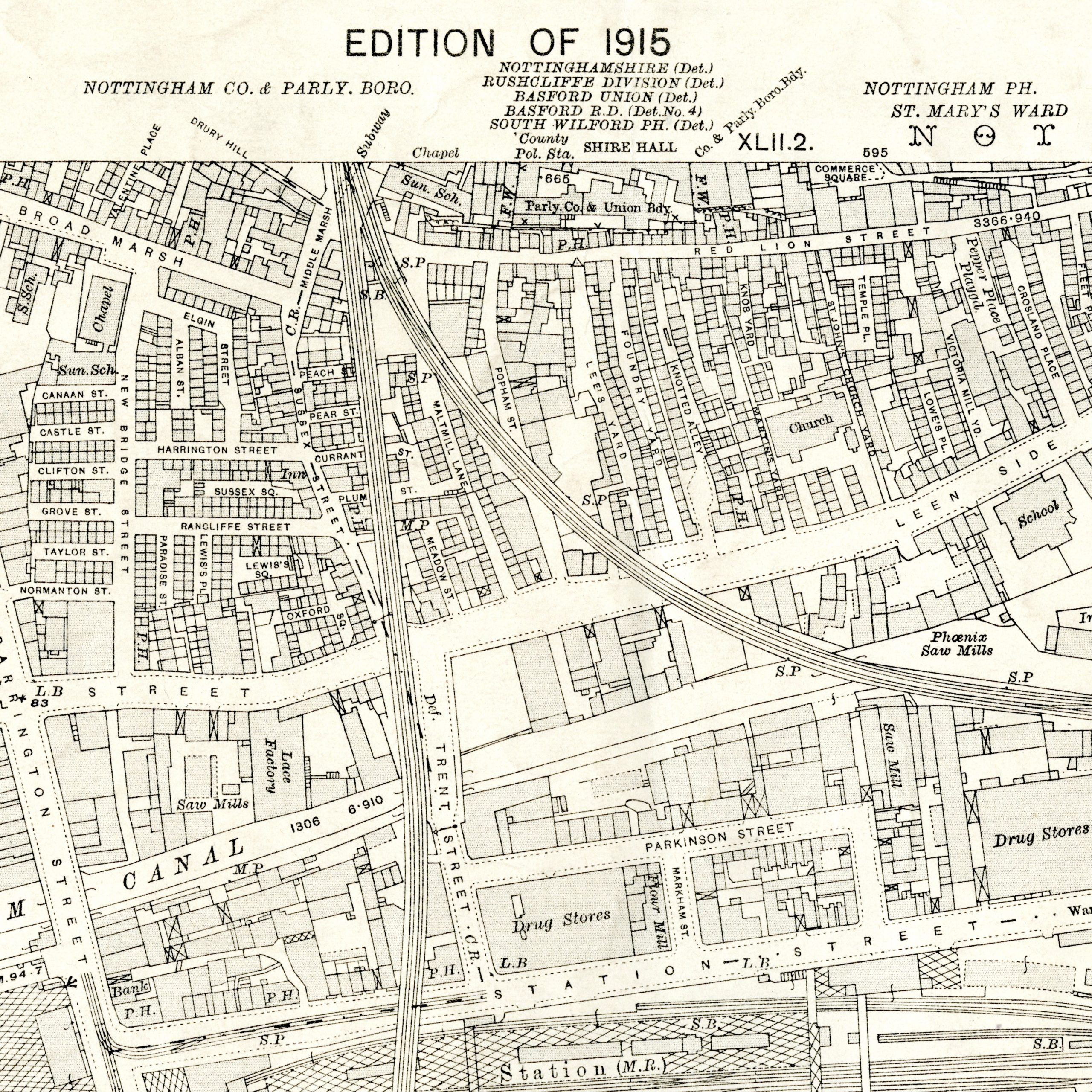
Figure 1, Ordnance Survey, 1: 2500, Nottinghamshire 42.6, Edition of 1915
Maps from the School Collection illustrate some of the stories. One such map (Figure 1) accompanies a story of the Rancliffe Arms on Sussex Street. From 1835, the Rancliffe Arms provided a home to an Operatives’ Library. It was one of a series of pubs in Nottingham to do this. Working people were able to pay a subscription to access a library of some 2,200 volumes[2] Such a connection between drink and education would have upset members of the nineteenth-century temperance movement. They presented environments such as pubs as degrading.
Campaigners even made maps of the pubs in some cities. This spatial evidence of their number and density was vital to temperance efforts to call time on drinking. They seemed to suggest that the ills of an area were an index of the number of pubs. By that measure, on the evidence of this 1915 map the area might not look too bad: there are pubs on Broad Marsh, two pubs on Red Lion Street (formerly Narrow Marsh), one on Leen Side, and a few on Station Street that would have served railway customers.
Even as licensing magistrates nationwide began to consider and control the number of pubs in different parts of towns and cities, this map points to the complexity of the drink question in late Victorian and early twentieth century Britain. In addition to sites of industry, the map shows that the area had densely packed and overcrowded housing, which reformers associated with gambling and intemperance. In this construction, drink seemed to be a function of the conditions of poverty as much as its cause. This epitomised an urban problem that could never be solved simply by closing a few pubs.
‘Thousands who earn a living do not know how to live’, wrote AR Henderson, the author of a history of Castle Gate’s Congregational Church published in 1905. Castle Gate was just a few streets to the north west of the area on this map, serving wealthier town and Park residents while looking also to the conditions of poverty just ‘a stone’s throw away’.
‘A day of monotonous toil is too often followed by an evening of debauch’, Henderson continued. ‘Recreation is one of the fundamental needs of the busy toiler. To find it in a home in the slums is wellnigh impossible. To look for it in the public-house or on the streets is to court temptation.’ As such, churches and the temperance movement saw part of their role as being to create an alternative social infrastructure to the pub.[3]
References and notes
[1] Salmon’s 1861 map has been digitised in sections by Manuscripts and Special Collections. These are viewable in the Maps and Plans section of their digital gallery. The Narrow Marsh section shows the Castle Gate Congregational Church.
[2] William Howie Wylie (1853) Old and New Nottingham (London: Longman, Brown, Green, and Longmans; Nottingham: Job Bradshaw, “Journal” Office) page 350. East Midlands Collection, Reference Not 3.D14 WYL.
[3] A.R. Henderson (1905) History of Castle Gate Congregational Church Nottingham, 1655-1905 (London: James Clarke & Co) East Midlands Collection, Not 3.M72 CAS.
Last Orders: Stories of Alcohol and Abstinence in the East Midlands co-curated by David Beckingham (School of Geography) and Manuscripts and Special Collections is on display at the Weston Gallery, Lakeside Arts, until 9 October.
Items from the East Midlands Collection can be consulted at the Manuscripts and Special Collections reading room, Kings Meadow Campus. An introduction to maps and plans is also available, with a link to a Guide to Nottinghamshire published maps [PDF] held at the archive.
Ordnance Survey items held by the School of Geography are catalogued in NUsearch. To consult them, contact collection curator Elaine Watts.
No comments yet, fill out a comment to be the first
Leave a Reply