April 10, 2024, by lzzre
Anticipating Genocide: An Ethnographic Map of Central Europe in 1942
A blog written by Professor Mike Heffernan
The School’s map collection includes many items from World War Two, evidence of the close relationship between cartography and war. One of the more eye-catching examples is a large, 1:1 million ‘Ethnographical Map of Central Europe’, printed in Budapest in 1942 with title and accompanying text in English. Mounted on a canvas base, the map is an exuberant riot of coloured dots, not unlike a pointillist abstract painting (Figure 1 for scale, and Figure 2 for detail).[1] But appearances can deceive. This is probably the most sinister item in the School’s collection, a vision of Nazi-dominated central Europe intended to justify invasion, occupation and genocide.
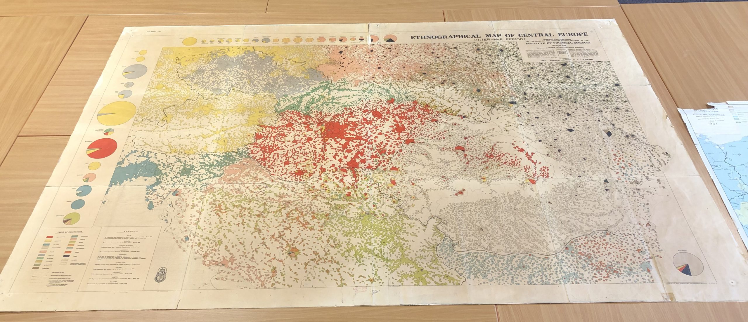
Figure 1 – click to enlarge
Centred on the Great Hungarian plain, the map depicts territories in ten interwar countries, from south-eastern Germany and north-eastern Italy to the Soviet Republic of Ukraine and the Black Sea coastlines of Rumania and northern Bulgaria. The region’s complex political geography, transformed by German military expansion, is indicated by separate lines for Hungary’s pre-1918 borders, the international frontiers between 1920 and 1938, and the 1942 borders, including those enclosing the German Protectorate of Bohemia and Moravia and the German-occupied General Government in Poland.
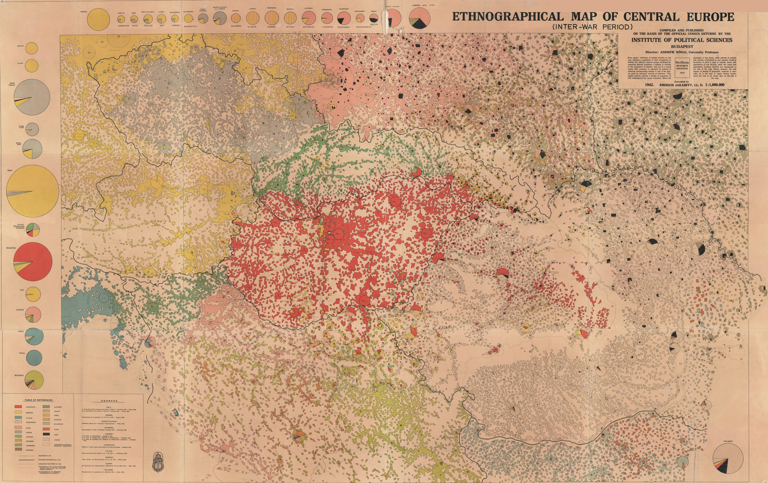
Figure 2 – click to enlarge
Notes on sources and methods, written in English and presumably intended for an international audience, indicate the huge effort involved in the map’s production (Figures 3 and 4). Data on seventeen ethnicities, gleaned from interwar national censuses, are displayed in vivid colours for areas with high population density where a single ethnic community predominated. Urban populations are represented by pie-charts of varying sizes divided into coloured segments for different ethnicities. Pie-charts for 34 of the region’s largest cities, from Trieste in the west to Lemberg (Lviv) in the east, are gathered around the map’s edges.
We don’t know when, why or how this map was acquired by the School of Geography. It is one of hundreds of thematic maps prepared before and during World War Two by the Hungarian Institute of Political Sciences (IPS), a semi-official agency established in Budapest in 1926 by Pál Teleki (1879-1941), a professor of geography at the University of Budapest who was also Hungary’s Prime Minister in 1920-1 and 1939-41. Copies of the map exist in several libraries around the world. The British War Office printed its own edition in 1944 for reasons that remain unclear.
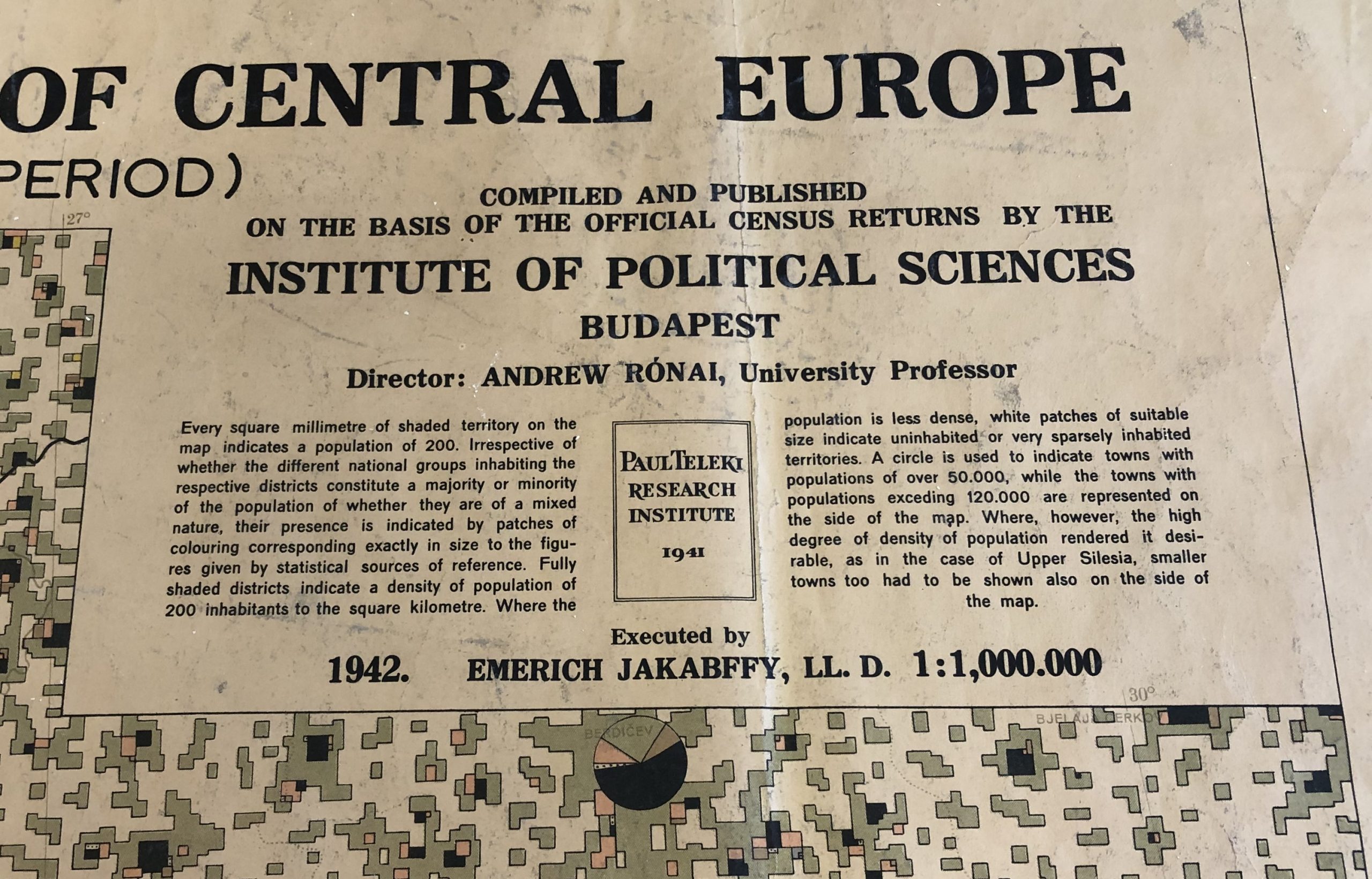
Figure 3 – click to enlarge
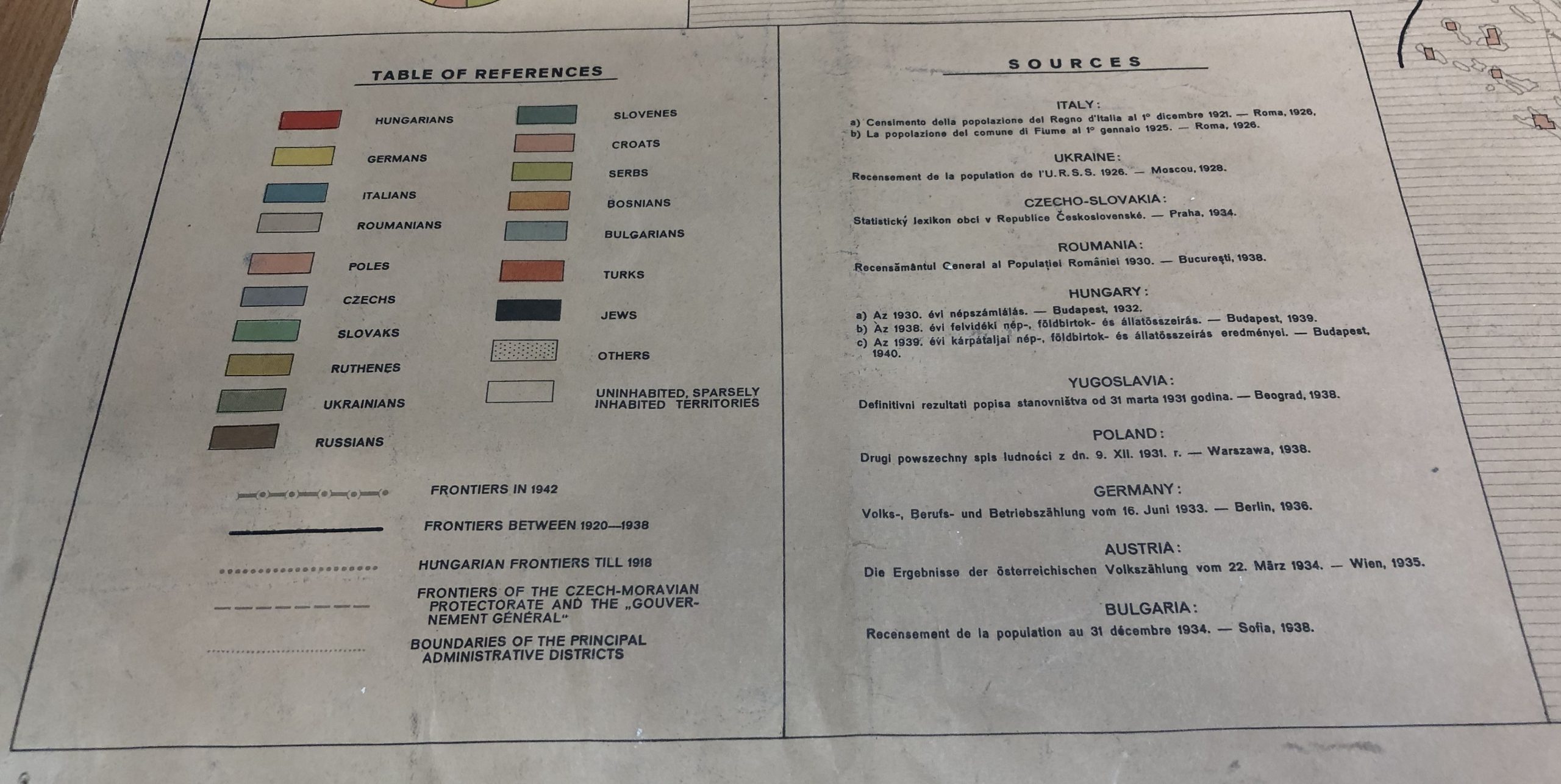
Figure 4 – click to enlarge
The map is a development of the Carte Rouge, a similar 1:1 million ethnographic map of pre-1914 Hungary designed by Teleki and prepared by the Hungarian Geographical Society in 1918-9 using data from the 1910 census of Austria-Hungary. An updated version of the Carte Rouge, named after the scarlet colour used to indicate areas where Hungarians were the majority population, forms the 1942 map’s bright red epicentre.
The Carte Rouge was the main piece of evidence presented by the Hungarian delegation in its doomed attempt to prevent the country’s dismemberment at the Treaty of Trianon in June 1920. This punitive accord obliged Hungary to surrender 64% of its pre-war territory and 72% of its population to neighbouring countries, chiefly Rumania (which acquired the whole of Transylvania, Teleki’s native region) and newly-established Poland and Czechoslovakia. The Trianon borders conformed to very different ethnographic maps prepared by advisers working for Britain, France, the United States and the new central European countries, including the geographers Isaiah Bowman, Jovan Cvijić, Viktor Dvorský, Emmanuel de Martonne, and Eugenius Romer.
The Carte Rouge lost the Trianon ‘battle of the maps’ but was soon adopted as the cartographic symbol of Hungarian irredentism. Simplifed versions of the map appeared through the interwar decades in school textbooks, atlases, postage stamps, and propaganda posters lamenting the injustices of Trianon. Teleki, by then a powerful politician, was determined that Hungary would never again be ‘outmapped’ by hostile neighbours. The task of the IPS was to provide bigger, better and more convincing ethnographic maps to justify the eventual return of territories and populations lost in 1920.
By the mid-1930s, the IPS had the largest map library in Central Europe, located from 1941 in the elegant salons of the Esterházy Palace in central Budapest. The IPS staff of 15 statisticians and cartographers, led by Imre Jakabffy, assembled a huge archive of cross-referenced information, much of it in cartographic form, on the injustices experienced by Hungarians living beyond the Trianon borders.
Germany’s influence on Hungary, always substantial, became irresistible after the rise of the Nazis whose geopolitical ambitions initially corresponded with those of Hungarian nationalists. The Munich Agreement, signed in September 1938 by Britain, France, Italy and Germany, forced Czechoslovakia to surrender the Sudetenland to Germany (thereby opening its remaining territory to imminent invasion) and open negotiations with Poland and Hungary about territorial claims in Silesia and Slovakia. Following the first and second ‘Vienna Awards’ in 1938 and 1940, Hungary almost doubled in size at the expense of Czechoslovakia, Rumania and Yugoslavia. IPS maps and statistical reports claimed there were Hungarian majorities in the reclaimed lands though interwar censuses suggested otherwise.
Teleki’s ethnographic obsessions raised many definitional problems, notably about Hungary’s Jewish community. While preparing the Carte Rouge, Teleki claimed Hungarian Jews were an assimilated religious community rather than an ethnic group and should not be identified on the map. During his tenures as Prime Minister, however, he introduced increasingly draconian anti-semitic laws, the first such restrictions in post-1918 Europe, initially to limit Jewish involvement in law, medicine, academia, and journalism, sectors previously dominated by the mainly urban Jewish community, and eventually to reclassify Jews as a racial rather than a religious community.
Teleki signed a tripartite pact with Germany and Italy on 20th November 1940 in the hope of preserving some measure of independence. Four months later, horrified at the prospect of German occupation, he committed suicide on the 3rd April 1941, leaving behind an infamous “I am guilty” note. András Rónai, Teleki’s protégé at the IPS (by then a department in the newly established Pál Teleki Research Institute) inherited most of his mentor’s academic positions. Rónai set about completing Teleki’s projects, including the 1942 ethnographic map and a thematic Atlas of Central Europe.[2]
According to the 1941 Hungarian census, there were more than 800,000 Jews in Hungary (5% of the population), 250,000 of whom lived in Budapest (c. 20% of the city’s population). The plight of Hungary’s Jews was increasingly desperate but they were at least protected from an even worse fate by the country’s precarious independence. When this ended with the German occupation in March 1944, the Jewish community was completely exposed to a now brutally efficient genocidal system. Between May and July 1944, more than 430,000 Hungarian Jews were deported on 147 trains, most to Auschwitz, where c. 80% were murdered on arrival. The killing continued for the remainder of the war.[3]
The black marks on Rónai’s map, used to represent Central Europe’s Jews, reveal the horrifying geographies of the Holocaust – actual, unrecorded and anticipated. Once thriving Jewish communities to the west of Hungary, in Austria and Germany, were no longer large enough in the censuses of the mid-1930s to register on the map. Jews were concentrated further north and east, the map suggests, in the towns and cities of Poland, Ukraine and Rumania, even though these huge populations, so prominent in censuses from the 1920s and 1930s, had already been eradicated by 1942 in countless unrecorded mass murders (Figures 1 and 2). The map also anticipated the destruction of Hungary’s still existing Jewish population. Budapest was apparently devoid of Jews in 1942, two years before this large and astonishingly creative community was deported to almost certain death (Figure 5).
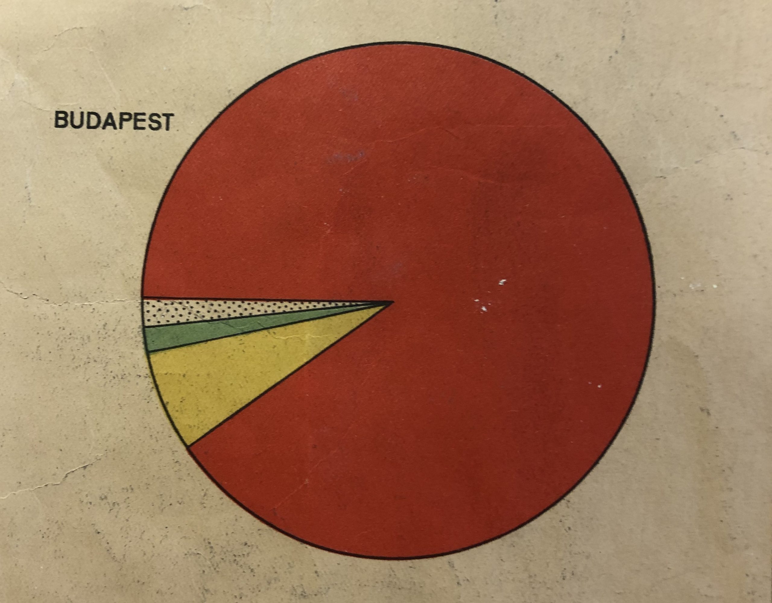
Figure 5 – click to enlarge
In a futile attempt to preserve his organisation, Rónai relocated the IPS archive to the lakeside town of Balatonfüred in 1945. Most of the material was seized by the invading Red Army, however, and subsequently disappeared into the Soviet Union. Under the newly installed communist regime, Hungary reverted to its pre-war borders, Rónai was dismissed, and both the IPS and the Hungarian Geographical Society were dissolved in 1948 and 1949 respectively.
[1] Thanks to Gary Priestnall for assistance scanning this unwieldly map.
[2] A few copies of the Atlas were published, in Hungarian and English, in March 1945 and a digital facsimile was produced by the Department of Cartography at the Eötvos Loránd University in Budapest in 1993.
[3] See Tim Cole (2003) Holocaust City: The Making of a Jewish Ghetto (London: Routledge) and several of his more recent articles
No comments yet, fill out a comment to be the first
Leave a Reply