September 5, 2014, by Graham Kendall
Life Cycle: As one ends, another begins
A couple of weeks ago, we reported on the start of Life Cycle 4. This took a team of 15 riders, 16 days to complete and the Vice-Chancellor maintained a blog, writing an entry at the end of each day. It is well worth a read if you have not seen it, if only to get some feeling for the task they undertook (almost 1400 miles in 16 days, sometimes in testing weather and hilly (if not mountainous) terrain).
I must admit I was an avid reader of the blog but as I read it, I thought about a research project that I was working on (which is not important in the context of this post) which used Google Maps to look at the driving routes between UK football clubs.
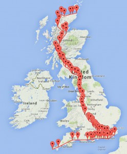
I thought it might be interesting to plot the route that the Life Cycle team made.
So, I trawled through the blog posts, noting all the locations that were mentioned. I then looked up their longitude and latitude (which is what Google Maps requires) and then plotted the route. This initial map can be seen here.
Mistake #1
If you zoom in, you see that there are a few strange things. For example, after getting to Brighton, the team (supposedly) went back to Southsea. If you look at the blog entry for this day (day 4), it says:
“We moved through Brighton, towards Eastbourne. Between Southsea and Eastbourne, there is a gruelling four mile climb to Beachy Head, followed by a very sharp descent into Eastbourne, where we ended up at Fusciardi’s Ice Cream Parlour on the front.”
The description is a little difficult to interpret definitively, but it certainly says that the team went through Southsea and it suggests that Eastbourne was visited directly after Southsea.
As a former systems analyst I understand some of the problems trying to get information out of the users that is agreed as being definitive by all concerned and usually you would refer back to the problem owner if there was something that needed clarifying. On this occasion, I thought that was a little churlish, not least of all as the author was heading towards Hastings, Rye and Hythe on a bike and would probably not respond (or take kindly) to an email seeking clarification!
I looked at the map and I think that the Life Cycle team probably went through Southease. In the final version of the map, I have replaced Southsea with Southease. At least it makes it look as if the team did not go back on themselves.
That was mistake number 1 (you’ll see why the number of mistakes is important later).
Mistake #2
You can see another section of the map where it looks as if they backtracked. On day 6, the blog said:
“Getting clear of Guildford was not straightforward. I think Esteban had his Spanish maps loaded! But, we got away eventually, through Camberley, Wokingham and Sandhurst, then skirting Reading to the north.”
This suggests the team visited Wokingham and then Sandhurst. I think that it is more likely that the order was Sandhurst and then Wokingham.
Mistake #3
On day 10, the blog said
“Everyone left at different times, to take the A75 northwest; Steve, Andy, Nieves, Penelope and Daniel left before Thornhill to take minor roads. We stayed on the A75 (as did Chris J, Karen, Marion and Svenja ahead of us). It is a good road which snakes through the river valley, undulating and attractive, but with a bone shaking surface for long stretches.”
and
“We stopped in Thornhill to get bananas, Boost bars, salted peanuts and Lucozade. After that, the only other stop we made was in Kilmochan, where we found a shop with a machine which dispensed tea, coffee and Bovril. Nick, Susan, Esteban and I arrived at the Dumfries Arms in Cumnock about 16:15.”
I was unable to find Kilmochan on Google Maps, and I also think instead of staying on the A75, the riders switched to the A76. Assuming that this is the case, then I think they must have passed through Kirkconnel, so I have included that on the final version of the map.
Mistake #4?
If you look at the map around the Inverness area, you might think that there is another mistake, as they appear to backtrack. In fact that was a deliberate diversion, as explained on day 13.
“We had ridden out the miles at a good pace and decided we would try and fit in a small treat – a visit to the Dalmore distillery in Allness. That meant heading up the A9 and over the Cromarty Firth, straight into a driving north easterly head wind. It was hard going. By the time we got there we had missed the last tour, but Andy (who was first in) persuaded the staff to give us a private tour, led by Shelley. The distillery enjoys a commanding position on the shore of the Firth, and has been producing single malt since the 1880s. It was a very informative tour.”
So, we do not count that as a mistake, but hope to share the spoils one day!
Mistake #4
On the last day the blog said:
 “The final 20 miles was fast, partly because the terrain changed completely and was pretty flat. We were also sheltered by massive sand dunes, and the sun was now smiling on us. And it was the final 20 of almost 1,400 miles, so it was second winds all round. Before you knew it we were lining up in Huma just outside John O’Groats for the finish. There was no sense of anti-climax, far from it.”
If you look up Huma on Google Maps you’ll see that it is China. What the blog should have said was Huna.
This was acknowledged as a mistake in the final blog post, which said:
“Karen pointed out we stopped at Huna, not Huma, to re-group and ride in to John O’Groats; and Chris J rightly scolded me that we had climbed 70,000 not 60,000 feet. I am happy to pay up for both, but especially the latter.”
The Final Map
After taking all the above points into account the revised map looks like this. At least there are no back tracking now (apart from the self-imposed distillery visit!).
So what?
 So what is the point of this blog post you might ask?
- It is certainly not to pick holes in the Life Cycle 4 blog. It is a very enjoyable read, written after a hard days riding, or early in the morning, and it really gets across the the challenges that the riders faced and they should all be congratulated for finishing the ride and raising the money they have (and continue to do) for a well deserving cause.
- It is not to say that the blog is wrong. For all I know I may have made mistakes. Perhaps they can be explained to me one day over a dram from the Dalmore distillery!
The reasons for writing this post are:
- It was an interesting exercise to plot the route on Google Maps so that we can see the tremendous effort that has been made. But doing that, inevitably led to some things that were not clear and needed to be looked at.
- It raises the profile of Life Cycle 4 again, now that the ride and blog have finished
- It might encourage you to contribute to this very worthy cause
- It enables us to mention own own Life Cycle Ride that UNMC are doing this Saturday (6 Sep 2014), followed by a charity carnival day at their campus in Semenyih
Who pays for the mistakes?
I said above that we were counting the mistakes for a reason. You’ll see from (real) mistake 4 that the Vice-Chancellor had to make a contribution to charity for any mistake he made in the blog (seems harsh, but there you go). I would not expect him to contribute for the three mistakes I believe I have found but somebody has to pay, so I will make a contribution to the UNMC Life Cycle event that is happening tomorrow.
A final comment on the maps
You’ll notice that the the two maps (version 1 and version 2) just plot the routes as straight lines. This is (of course) not accurate, so we implemented another Google Map that lets you interactively play around with the driving distances.
The number of way points you can choose is limited to (I think) eight, but you can still have fun with it and, importantly, it will tell you the distance between two locations as if you had driven.
Perhaps the best one to try is Land’s End to John O’Groats, with way points of Hythe and Tongue, as these are the four corners of the UK that the riders had to reach.

Just to be on Graham’s side – he has paid the fine! 🙂