January 15, 2015, by Emma Thorne
The Grandest views
As inhabitants of our 21st century world it’s almost unthinkable for us to imagine an age when seeing the rolling hills of the British landscape laid out like a patchwork quilt below would have been as alien as the surface of the moon.
These days while we need only glance out of the window of our holiday jet or take to Google Earth to get a sense of the awesome scale of the surroundings in which we live, we rarely really appreciate it.
Not so for Dr Gary Priestnall in the University’s School of Geography. His research exploring what was the first ‘mathematically accurate’ 3D relief model of the Lake District has given him a unique insight into the wonder with which it would have been greeted by Victorian tourists visiting the area when it was first unveiled in Keswick in 1875.
His work, which has been based around what is believed to be the one last surviving, beautifully hand-painted piece of the 15-foot square model, as well as some of the original plaster moulds used to create it, has spawned a new exhibition due to open at the beginning of February and will be featured on the BBC’s Countryfile programme this weekend.
Dr Priestnall said: “Physical relief models offered visitors unprecedented views of a landscape long before it was common to plan a trip using maps or to have seen an aerial image. Mayson’s Ordnance Model of the Lake District was innovative in attempting to provide such an accurate and faithful landscape model as a visitor attraction. The attention to detail in the model was incredible. It is hard to imagine what an impact this would have had on visitors who would not have seen anything like it before.”
Photographer Henry Mayson and his brother Thomas who commissioned the model from sculptor Raffaele Monti came up with the perfect Unique Selling Point for their attraction. Visitors flooding into the area from the newly constructed railway were told that it was the most accurate 3D representation of the landscape they were likely to see, and that it was faithful to the relatively new Ordnance Survey maps which had become de rigueur. Posters at the railway station informed visitors that “they will gain a better idea of the whole of the Lake Country than is to be obtained from any other source”.
The model, which included intricate details of the landscape in a six inch to one mile scale, was housed in the Maysons’ photographic studio on Lake Road, Keswick. This building was on the main route taken by visitors from the railway station down to the popular viewpoint at Crow Park on Derwentwater. Keswick was becoming a major gateway to the Lake District for the rest of the UK during the emergence of Victorian tourism. At a time when maps and travel guides were expensive and aimed largely at wealthy travellers, the Mayson model became the first stop for people arriving from large industrial cities like Manchester and Glasgow so they could plan their itineraries and walking tours.
By the 1970s, the model and photographic studio had fallen into disrepair. Attempts to find any remaining pieces of the Mayson model have so far failed.
However, one original tile thought to be sample produced by the sculptor, and 140 negative moulds that were used in the creation of the model were recovered from storage recently. Dr Priestnall has worked with Dr Katharina Lorenz at the University’s Digital Humanities Centre to digitally capture the moulds using a high-precision laser scanner. These laser ‘point clouds’ were then processed and digitally inverted using a Geographical Information system (GIS) within the School of Geography.
Next, a team at the University’s Centre for 3-D Design led by Sarah Thomas used the detailed digital data and the latest milling technology to produce authentic blank replicas of the some of the model’s tiles.
The results will be on show at a new exhibition which will be unveiled on Monday 9th February at Keswick Museum and Art Gallery, not far from the building which housed Mayson’s model and which now contains several retail units.
The exhibition has been created by Dr Priestnall in collaboration with the museum’s Curator Sue Mackay and is being run in partnership with Ordnance Survey.
It will feature the opportunity to see the last remaining original tile, the original Ordnance Survey maps used to create the model, and many of the posters used to advertise the model. Also, a floor map of the Lake District at the scale of the original model will place several digitally reconstructed replica pieces into context, raised above the floor map on plinths. Modern technology will also be used to project a series of layers of different types of maps, imagery and animation onto a larger section of replica model to give a sense of the developments in land cover mapping since Victorian times.
Bringing the story right up to date, a thrilling virtual ride over the Lakes will be provided by modern digital modelling techniques constructed from current Ordnance Survey data.
Dr Priestnall added: “Digital techniques offer many ways to present landscapes to visitors in engaging ways, and to let them explore dynamic virtual models. Something that can be difficult to convey via a computer screen however is the broader landscape overview, which allows people to understand the spatial relationships between places of interest. This is something that physical relief models do very well. Today we have many options for digital survey of the landscape, much of which takes place from aircraft, coupled with 3D printing and milling, so we have a great opportunity to explore the power of physical models again using digital technology to help create them. I believe that physical landscape models can play an important part in the modern visitor experience.”
The new exhibition, The Grandest Views: Models of Lakeland from Victorian Times to the Present Day, will feature on Countryfile at 6.30pm on Sunday 18th January on BBC One.
-
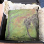
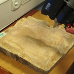
- The original remaining handpainted Mayson model tile
-
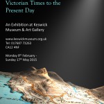
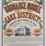
- A flier for the new exhibition at Keswick Museum
-
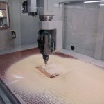
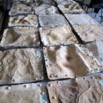
- The milling process for creating the blank white tile replicas
-
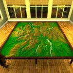
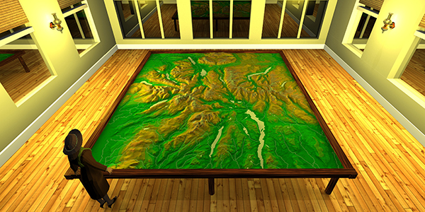
- A mockup of how the Mayson model would have looked.
-
- The original Mayson model moulds.
-
- A vintage poster advertising the Mayson model to tourists.
-
- Scanning an original Mayson model mould


[…] Most recently, Dr Gary Priestnall from the School of Geography was interviewed about his involvement in an exhibition on the Mayson model, a 15-foot 3D model that helped Victorian visitors to plan their tour of the Lake District when arriving by train in Keswick in the 1870s. […]