November 24, 2015, by Matt
50th Anniversary of Hoggar Mountains Expedition to the Sahara
Many thanks to Dennis Jones for providing us with these images and account of a UoN expedition in 1965. After receiving a BSc in Geology in 1966 Dennis had a successful career working in the exploration and mining industries – his brief cv follows his post.
As with so many important events in one’s life, the Hoggar Mountains Expedition to southern Algeria, undertaken 50 years ago by a small group of geologists from Nottingham University, started out almost by chance. As undergraduates in the (now defunct) Department of Geology we were expected to complete a geological mapping project in the last year of our studies, either in the UK or at the university’s field school in Norway. One of those in our group had seen photographs of the spectacular scenery of the Hoggar Mountains and read about its equally fascinating geology and he thought it would be a wonderful place to do our mapping. At that stage, logic should probably have kicked into gear and listed all the reasons why it was a foolish proposition. But for some reason, it didn’t happen that way. Slowly at first, but then with increasing confidence and determination, we started to assess what steps we would have to take in order to realize our goal. Not least of these was the task of persuading our professors — and also our parents — that it really was a good idea. To their great credit, and with our everlasting gratitude, they agreed and then all that was left to do was to raise the funds to buy a suitable vehicle and equip the expedition.
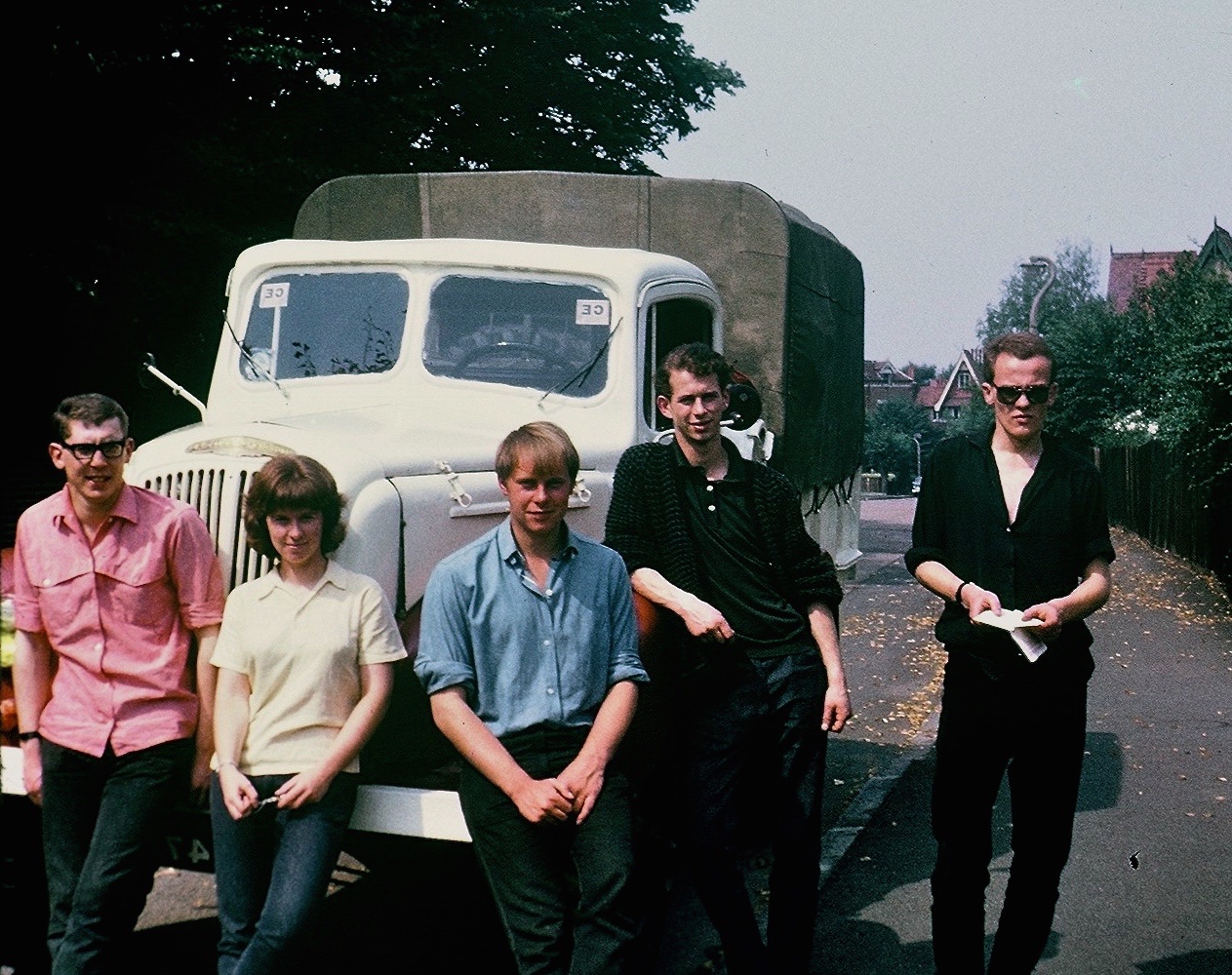
After securing the endorsement of the Nottingham University Expeditions Co-ordinating Committee, our small group left England on August 12, 1965, bound for the Sahara. There were four geologists in the party — Bridget Youngs, Rod Baker, Tony Gallon and myself, Dennis Jones. In addition, there were two non-geologist friends, Chris Righton and Jill Canham.
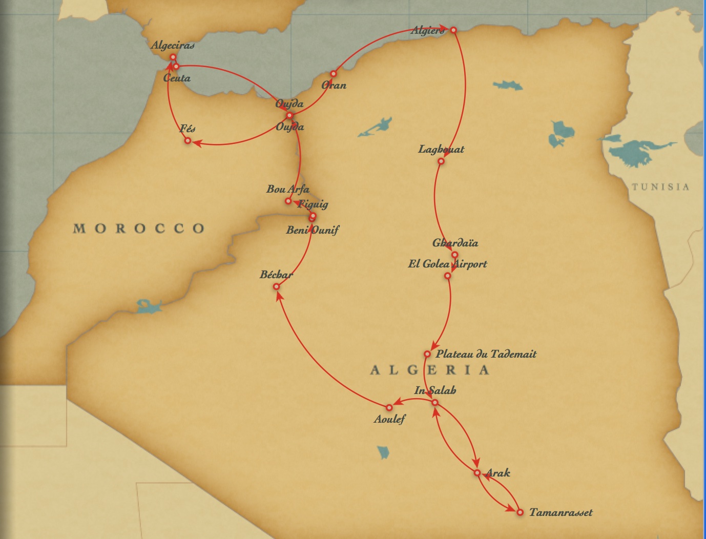
After driving through France, Andorra and Spain we reached Algeciras from where we took the ferry to Ceuta in Morocco. And on August 22, 10 days after leaving England, we arrived in Algiers.

Laghouat, 450 km south of Algiers, is generally accepted as the start of the true desert and another 450 km beyond that the tarred road came to an end at the large oasis of El Golea and from there we had to make our way south across the desert by following the tracks of trans-Saharan truck convoys. One day after leaving El Golea and driving across 300 km of rough gravel desert that forms the high Tademait Plateau, we pulled into the oasis of In Salah, one of the hottest places on earth (temperatures reach in excess of 55 °C).
On September 2, 20 days after leaving England and 2,000 km south of Algiers, we reached our goal of Tamanrasset, home of the Tuaregs in the heart of the Hoggar Mountains.
Before starting our geological mapping, we set up our camp at the base of Iharen, one of the many prominent volcanic plugs in the Hoggar Mountains. The region is characterized by these relatively recent trachy-phonolite plugs which punctuate the ancient basement rocks of granite and gneiss to reach heights of over 200 m above the desert floor. These unusual plugs, as well as cliff-forming basalt and rhyolite flows, are what makes the topography of the Hoggar so unique.
Once our mapping was successfully completed, we drove to the Atakor, the highest part of the Hoggar, and it was here, much to our surprise, that we ran into heavy rain, not at all what one expects in the Sahara. It did not augur well for our return journey north through the desert.

The rain soon cut up the track and we later learned that no vehicle apart from army convoys had passed through this area for the last two weeks due to the effects of the rain. The next day we came across an extraordinary sight — four, 30-ton trans-Saharan trucks bogged down in mud. They had been stuck for five days! Not wanting to suffer the same fate, we chose what looked like a firmer route through the area but as we carefully moved forward we sank down into the mud until the back axle was almost submerged in mud. The situation looked hopeless and the temperature was 46 °C but after unloading the truck and digging the mud and sand from around our tyres, some four hours of hard, sweaty work later we managed to drive our way out of the deep muddy hole.
It was a relief to reach solid ground, but later that afternoon we had our first mechanical problem with the truck — the auxiliary gearbox had jammed in neutral. We managed to fix it — as it turned out, only temporarily — and we crossed the border from Algeria to Morocco, escorted by soldiers past high barbed wire barriers and through more than a kilometre of no-man’s land with land mines on either side due to a border dispute.
In Morocco, and back on a tarred road for the first time in weeks, we experienced more problems with the gearbox, serious enough that it took four days to fix it and we could not have done it without the help of two local mechanics who manufactured spare parts.
With our truck back in good running order and with many memories of a wonderful trip, we headed for the ferry which would take us to Algeciras — and home.
Curriculum Vitae of Dennis Jones
Mr. Jones received a B.Sc. in Geology from Nottingham University in 1966 and a M.Sc. in Economic Geology from the University of Toronto in 1975.
Dennis spent 40 years working in the exploration and mining industries, retiring in 2005 from the position of Vice President Exploration for Iamgold Corporation, a Canadian gold mining company. During his ten years with Iamgold, he led the exploration teams which discovered the +3 million ounce Quimsacocha gold deposit in Ecuador and which did the initial drilling on the +2 million ounce deep-sulphides deposit of the Sadiola gold mine in Mali.
Before his time with Iamgold, Mr. Jones ran his own consulting company, GeoQuest International Inc., which offered a wide variety of services to the minerals industry.
Since retiring Mr. Jones has been heavily involved on a volunteer basis with the Prospectors and Developers Association of Canada, of which he is a Director. He is Chair of PDAC’s Corporate Social Responsibility (CSR) Committee which launched the website “e3 Plus: A Framework for Responsible Exploration” to encourage exploration companies to improve their CSR performance in the fields of social responsibility, environmental stewardship and health and safety. Mr. Jones was a representative on the Advisory Group to the Canadian government during the 2006 National CSR Roundtable meetings on extractive industries working abroad.
In his earlier career, Dennis Jones worked for seven years as a Project Manager on mineral exploration projects with the United Nations in South America and Cyprus and before that was a consultant with various companies. His first position in mining was as Mine Geologist for the Iron Ore Company of Canada.
No comments yet, fill out a comment to be the first


Leave a Reply