February 17, 2021, by Blue-Green team
Upstream Natural Flood Management (NFM) influencing downstream drainage
In this blog, Dick Fenner and Charlie Ferguson explore how Natural Flood Management (NFM) strategies in upstream rural parts of a catchment might influence the performance of urban drainage systems further downstream (through moderating water levels in urban watercourses).
Catchment-based flood management
It is estimated that there will be a general increase of between 5 and 25% in river flows during wet seasons in parts of England (Committee on Climate Change, 2016). To combat this a catchment-based flood management philosophy has emerged in recent years, which aims to use a series of spatially discrete interventions to evolve rural catchment uplands and reduce risk of downstream fluvial flooding (Lane, 2017). In certain catchments the use of NFM interventions will also influence how the downstream receiving watercourse interacts with urban drainage outfalls. Whilst the evidence for catchment scale NFM mitigating fluvial flooding in extreme rainfall remains inconclusive (Iacob et al., 2017), NFM solutions may improve the resiliency of urban surface water drainage during lesser events by moderating water levels in urban watercourses. This would reduce the submersion of frequently drowned drainage outfalls and promote free discharge from the urban system and thereby improve the effective capacity of the network.
There are several examples of detrimental impacts from inundated surface drainage outfalls, for example with outfall flaps in Birmingham being closed because of high water levels in the nearby River Rea (Ellis and Viavattene, 2014) leading to greater flood risk. Similarly the restrictive impact of high water levels in local streams on the surface water network in the Kent town of Paddock Wood has been identified as a critical flooding mechanism (Jackson Hyder Consulting, 2015). In Kingston upon Thames town centre and nearby Hogsmill Valley, high water levels in the local watercourse have been reported as blocking outfalls and creating extended periods of surcharging in the surface drainage network (Craven and Littlewood, 2011).
The 4 separate “flow states” in an urban watercourse with a flapped urban surface water outfall are shown in Figure 1 below:
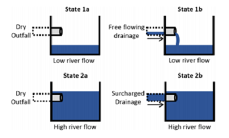
Figure 1: Different flow states in an urban watercourse with a flapped surface drainage outfall (Ferguson and Fenner, 2020a)
Modelling approach
To study these effects a novel coupled modelling approach was adopted linking:
- Dynamic TOPMODEL (a long established semi-distributed and semi-conceptual hydrological response model which discretises a catchment into hydrologically similar Hydrological Response Units), with a
- 2D HEC-RAS model (which solves the full shallow flow equations using a finite element method and allows channel flows to be predicted at a downstream gauging station), with an Integrated
- INFOWORK ICM model (which provides the drainage response from the urban area with respect to changes on outfall inundation)
Details of the modelling methodology and the calibration procedures used can be found in Ferguson and Fenner (2020b).
Results from Case Study Catchments
The Bin Brook, Cambridgeshire
The Bin Brook Catchment (~18km2) is part of the Cam and Ely Ouse river basin in Cambridgeshire and drains an area west of Cambridge passing through rural, intensely farmed land before entering the city and draining to the River Cam in the city centre. There is a significant flood risk for an area of housing located on the fringe of Cambridge with 28 properties flooded in 2001 and several instances of surcharging and nuisance surface flooding reported since.
The impacts of four NFM scenarios were tested including the introduction of woody debris and wider catchment afforestation, and attenuation of the catchment response created by these measures was evaluated for a historic event and six different design storms.
The water depths at two downstream drainage outfalls was investigated with respect to maintaining free discharge from the drainage system. The results showed that the greatest reductions in the time of outfall inundation from NFM occur during frequent storms. These reductions diminish with storm severity but, by slightly desynchronising rural and urban responses, upstream interventions have a modest benefit for downstream drainage performance (in this case preventing the system capacity being exceeded during a 1 in 100 year event).
The full results of this study have been published in the Journal of Flood Risk Management (see Ferguson and Fenner (2020a)).
The River Asker, Dorset
The River Asker drains a 48 km2 area of western Dorset before passing through Bridport and then discharges into the English Channel. The catchment is principally grassland with pockets of arable farming and woodland. Water levels in the River Asker have influenced surface flooding with drainage unable to cope during intense pluvial events, frequently submerging an outfall from a nearby housing estate. Two forms of upstream catchment scale interventions were modelled to understand their impacts on the functioning of the drainage network during both the calibration period and for a range of design storms.
The results indicate the NFM interventions have the greatest impact on surface drainage performance during frequent storm events. For example, during a 1 in 10 year storm upstream NFM could reduce outfall inundation by 3.75 hours and remove any surcharging within the drainage system in Bridport. In more severe storms, the results suggest interventions could slightly prolong the time the outfall was submerged. By slowing the wider catchment response, upstream interventions allow more water to escape the urban drainage systems and reduce the maximum surface flooding extent within the housing estate by 35%.
The full results of this study have been published in the Royal Society’s Philosophical Transactions A (see Ferguson and Fenner (2020c)).
The River Calder, Yorkshire
The study focused on Todmorden in the headwaters of the Calderdale valley in West Yorkshire which was the UK’s worst affected borough during the Boxing Day floods in 2015 with over 2500 properties impacted, following previous serious flooding in 2012 and 2013, as well as more recently in February 2020. Local authorities believe that blocked surface drainage outfalls (resulting from heightened water levels in receiving urban watercourses) exacerbate surface flood risk (Calderdale Metropolitan Borough Council, 2019). Whilst the sub-catchment studied has no significant NFM projects currently underway, the recent flood history has fuelled projects across the wider Calderdale area. Two forms of potential interventions were studied including in-channel woody debris and cross slope tree planting. These were chosen because they reflect several physical implementation projects within adjacent sub-catchments of the River Calder and together they represent the impact of significant changes in land management practices in upper Calderdale.
The results suggest that catchment-scale tree planting and in-channel woody debris create modest benefits to the downstream drainage system in parts of Todmorden. Under frequent storm events (e.g. a 1 in 1 year storm) the inundation of low lying areas is completely removed. As storm severity increases (and surface flooding becomes an issue), impact from upstream NFM attenuation on outfall inundation durations diminishes significantly. However, the delay in rural response allows more water to escape surface water pipe systems, increasing the effective capacity of networks and reducing surface flooding. For instance, outfall inundation during an estimated 20 year event is delayed by 30 minutes which results in up to 25% reduction in surface flood volumes. While the benefits are limited in extent, the modelling indicates that NFM can moderate water levels and help improve downstream surface drainage performance in the area.
The full results of this study have been published in the Journal of Hydrology (see Ferguson and Fenner (2020c)).
Further work was carried out on the Calder catchment examining the urban responses under various storm tracks, based on five design events and eight different storm directions (Figure 2).
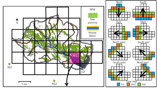
Figure 2: Calder Catchment with hypothetical NFM scenario and overlaid variable rainfall grid showing first three time steps of eight different storm directions (Ferguson and Fenner, 2021).
The results shows that Todmorden’s surface drainage is influenced by the degree of synchronisation between urban rainfall and heightened levels in the receiving watercourse. In particular, storms from the north and west lead to synchronisation of urban rainfall and outfall inundations, which hinders drainage performance. Conversely south and east storms result in the urban rainfall passing through the drainage system before outfalls are impeded.
The full results of this study have been published in the Journal of Water Management (see Ferguson and Fenner (2021)).
Overall Conclusions
Taken together these studies have shown that NFM interventions in upper rural catchments can contribute to water level management strategies by moderating water levels and promoting free discharge at surface drainage outfalls in downstream urban areas. In each catchment there is a “window” of events (defined by storm track and severity) where NFM could improve surface drainage performance and mitigate nuisance flooding in urban areas. The benefits are modest but could help engage local stakeholder and community support for wider catchment based mitigations.
References
- Committee on Climate Change 2016 UK Climate Change Risk Assessment 2017 Synthesis Report (https://www.theccc.org.uk/wp-content/uploads/2016/07/UK-CCRA-2017-Synthesis-Report-Committee-on-Climate-Change.pdf)
- Lane S.N. (2017) Natural Flood Management. Wiley Interdicsip. Rev. Water 4, 1-14 (doi:10.1002/wat2.1211)
- Iacob O, Brown I., Rowan J., (2017) Natural flood management and climate tradeoffs : The case of the Tarland catchment, Scotland. Hydrological Sciences Journal 62(12) 1931-1948 (doi:10.1080/02626667.2017.1366657)
- Ellis J.B., and Viavattene C. (2014) Sustainable Urban Drainage system modelling for managing urban surface water flood risk. Clean Sol, Air, Water 42 (2) 153-150 (org/10.1002/clen.201300225)
- Jackson Hyder Consulting, (2015) Jackson Wood Flood Alleviation Study. Guildford. Retrieved from: https://www.kent.gov.uk/__data/assets/pdf_file/0004/35455/Paddock-Wood-SWMP-stage-2-report.pdf
- Craven E. and Littlewood S., (2011) Surface Water Management Plan for the Royal Borough of Kingston upon Thames. Thames Water; Environment Agency; Greater London Authority; Royal Borough of Kingston.
- Ferguson C., Fenner R.A, (2020a) The potential for natural flood management to maintain free discharge at urban drainage outfalls. Journal of flood Risk Management (doi:10.1111/jfr3.12617)
- Ferguson C., and Fenner R.A. (2020b) The impact of Natural Flood Management on the performance of surface drainage systems: A case study in the Calder Valley. Journal of Hydrology 590, 125354 (org/10.1016/j.jhydrol.2020.125354)
- Ferguson C., and Fenner R.A, (2020c) Evaluating the effectiveness of catchment-scale approaches in mitigating urban surface water flooding. Philosophical Transactions of the Royal Society A, 378, 2168 (org/10.1098/rsta.2019.0203)
- Calderdale Metropolitan Borough Council (2019) Initial Event Analysis Report. Retrieved from https://www.calderdale.gov.uk/v2/sites/default/files/Initial-Event-Analysis-Report.pdf
- Ferguson C., and Fenner R.A. (2021) How natural flood management helps downstream urban drainage in various storm direction. Proceedings of the Institution of Civil Engineers – Water Management (org/10.1680/jwama.19.00057)
No comments yet, fill out a comment to be the first
Leave a Reply