06/11/2024, by aezcr
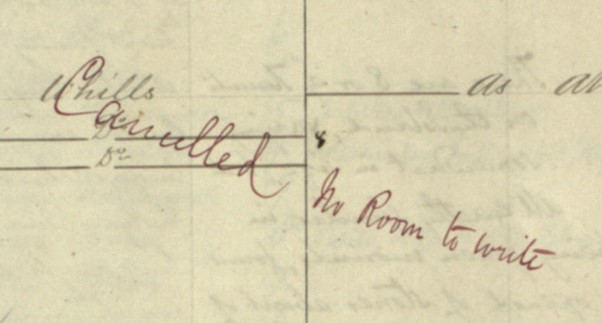
‘Cancelled, no room to write’!
The Ordnance Survey Name Books are a valuable and productive resource for place-names research… but for places like the small island of Fair Isle it seems there just wasn’t enough room to write all the names that were collected onto the map!
A bit of background first: these books contain place-name information and the sources for that information systematically gathered by officers of the Ordnance Survey to inform the drawing of maps. What they recorded varies a little, but all essentially contain columns that include the ‘name – as written on the plan’, the ‘various modes of spelling the name’, the ‘authority’ for those spellings (that is, named people from the islands such as teachers, farmers, factors etc.), ‘situation’ and ‘descriptive remarks’. The books for the Highlands (and Islands) were ‘essentially a “field” version of the name book’ for which the officers also consulted with ‘local historians and etymologists (authorities) in order to fix the spelling (the received name) of each “object” (natural feature, inhabited place, building and so on)’ (Scotland’s Places). It is clear from the volumes that a certain amount of editing was carried out by staff back at the office, so to speak, and that this post-fieldwork activity involved the addition of data collected from other ‘sources such as early maps, historical texts or local scholarly bodies’ (Scotland’s Places). Indeed, one source for some of the Orkney name books is Orkneyinga saga!
As well as the twenty-six volumes that cover Orkney (containing 8788 entries and surveyed in 1879-80) a further twenty-six volumes cover Shetland (containing 11980 entries and surveyed in 1877-78). For the Ragna’s Islands project we’re making use of Orkney volumes 13 (which contains North Ronaldsay), 26 (which contains Papay), and Shetland volume 11 (which contains Fair Isle).
Each volume has been transcribed on the Scotland’s Places website and the transcriptions sit alongside the digital images for each page. The place-names can, helpfully, be browsed in alphabetical order. Some of the ‘names’, however, refer to a ‘cairn’, ‘tumulus’, ‘stone cist’, ‘standing stone’ etc., and so in practice there are fewer actual place-names. Having said that, these particular entries can be instructive in terms of, for example, the archaeological and folkloric information they provide. A good illustration is this entry from the Fair Isle volume which remarks on tumuli near Sheep Craig, it reads:
‘There are 8 or 9 Tumuli on the Island, varying somewhat in size, but all exactly similar in appearance, being green mounds, found to consist when opened of stones about of the size used for road metalling. The people of the island call them “Fairy Knowes” or “Gude Folks’ Knowes”, – & do not remove them even when they are in a cultivated field. Urns have been found in some of them made of steatite or clibber stone. They are no doubt sepulchral mounds of a very ancient date, although no bones have been found in them; the urns probably contained ashes.’
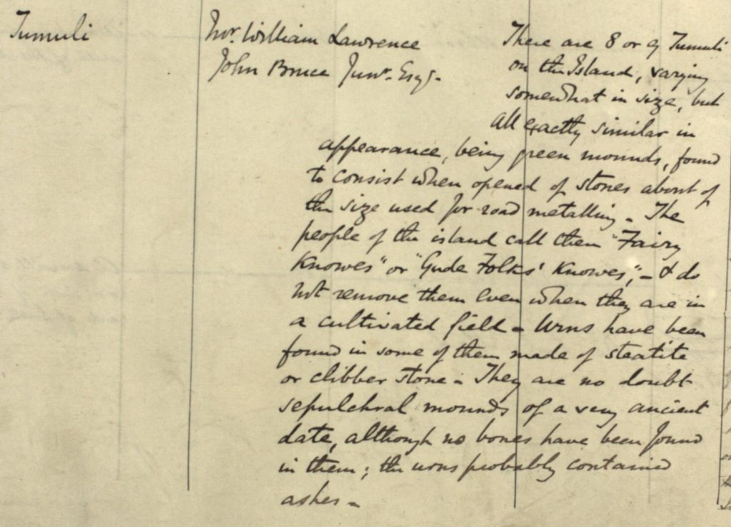
Detail from the manuscript name book for Fair Isle. OS Name Books, 1877-1878 Shetland, Volume 11, OS1/31/11/92.
For the three islands we’re researching, the ‘island’ entry (not necessarily the first entry) contains a brief description of the island and records, by name and where they lived, who the authorities were for the spellings of the place-names. A nice example is the Fair Isle volume which contains detailed information about the island’s population, as well a commentary on fishing, crofting and weaving and knitting at the time that the 1877-78 survey was undertaken.
Now back to the reason behind the title for this blogpost. There is an interesting note on page 3 of the Fair Isle volume, it reads ‘I have cancelled a good many names on this Book, but there still seem to be more on the plan than necessary’.

Detail from the manuscript name book for Fair Isle. OS Name Books, 1877-1878 Shetland, Volume 11, OS1/31/11/3
And further on in the volume we find the following entry:

Detail from the manuscript name book for Fair Isle. Shetland OS Name Books, 1877-1878 Shetland, Volume 11 OS1/31/11/91.
So, the officer in the field had collected too many names whilst surveying Fair Isle to include on the finished map, and not only that, despite a number of ‘cancellations’ back at the office… there were still too many! Happily, however, even though many names are struck through in the volume, we can still make them out. The name that is cancelled above is ‘Whills’ which refers to the ‘narrow and impassable ridge’ that connects Fair Isle to Sheep Craig (also known as Sheep Rock), perhaps from ON hals ‘neck, ridge, mountain pass’ (ONP).
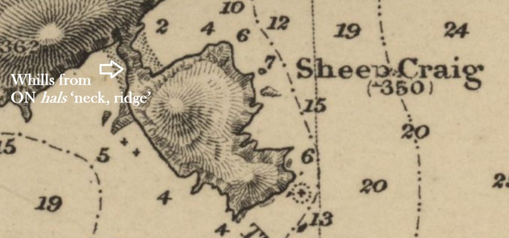
Detail from the 1895 Hydrographic Office admiralty chart for Fair Isle showing Sheep Craig and the narrow neck of land between it and the island. Admiralty Chart 2622) Reproduced with the permission of the National Library of Scotland.
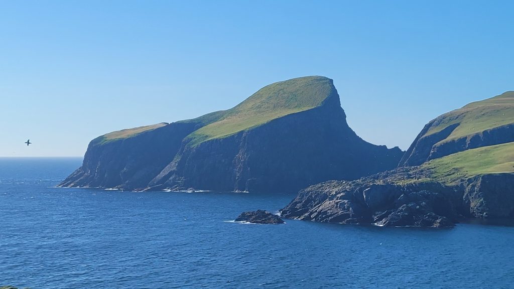
Sheep Craig, with narrow neck of land called ‘Whills’ joining it to the main island.
As part of the present project, we’re hoping to capture these ‘cancelled’ names to include in the place-names database we’re putting together as they are, perhaps, an unmined source of information that could tell us more about the topography and archaeology of the islands we’re researching. Until then however, these are our favourite Ordnance Survey Name Book entries… so far… for each island…
From Fair Isle, Engan Roo. This is a favourite because of the ‘Onion Ru’ spelling provided by the informants on the island, or perhaps more likely, the pronunciation that the OS officer in the field heard and attempted to spell. Either way the spelling perhaps hints at the pronunciation of the place-name some 147 years ago.

Detail from the manuscript name book for Fair Isle showing ‘Engan Roo’ and ‘Onion Ru’. Shetland OS Name Books, 1877-1878 Shetland, Volume 11 OS1/31/11/91.
For Papay, it has to be ‘Quiborni Geo’ which caught our attention because, having been working on the place-names of Papay for some time, it had seemed to escape us. So, we had a look for it on the modern OS and found it to be rendered ‘Kweevnie Geo’. It seems to be recorded as such on the OS from at least the 1970s and as indeed it was by Marwick in his publication some forty-five years after the survey.

Detail from the manuscript name book covering Papa Westray showing ‘Quiborni Geo’. Orkney OS Name Books, 1879-1880, Volume 26, OS1/23/26/49.
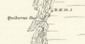
Detail form the 6” OS map for Papa Westray showing Quiborni Geo, Orkney. Sheet LXXI, 1882. Reproduced with the permission of the National Library of Scotland.
Of the ‘Kweevnie’ spelling, Marwick states that there are three such geos in Papay (North, Middle and South), and suggests a meaning derived from the Norwegian kviva ‘to hum, whine, whistle, whizz’ (Marwick, ‘Papa Westray’, p. 41). Again, this early OS name book spelling perhaps indicates how the place-name sounded when pronounced to the OS officer, and that this had later been altered and the mapping updated, perhaps based on Marwick’s survey some forty-seven years later.
Finally, for North Ronaldsay it’s another ‘cancelled’ name ‘Finnerhouse’.
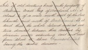
Detail from the manuscript name book for North Ronaldsay describing ‘Finnerhouse’. Orkney OS Name Book, 1879-1880 Volume 13 OS1/23/13/32.
Marwick described the ‘Finyerhus’ as a ‘high round cultivated brae’ and ‘an ancient house site’ probably derived from ON vinjar-hús ‘pasture-house’ or possibly vinjar-áss pasture-ridge’ which may describe the brae, that can still be seen, remarking that ‘vin was practically, if not wholly, obsolete before the Viking age’ and therefore regarded the place-name as one of the very oldest on the island (Marwick, ‘North Ronaldsay’, p. 60).
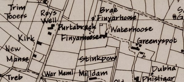
Detail from the map drawn by Karl Cooper, ‘Place-Name Survey, The Island of North Ronaldsay, Orkney’ c.1983, showing ‘Finyarhoose’ and the ‘Brae o’ Finyarhoose’. (North Ronaldsay Archives).
Sandnes, while discussing another vin– name (Vinquin, Evie) remarks that the element is ‘an archaic word for pasture or natural grassland… found in Norwegian names of high age’ (Sandnes, pp. 155, 263). Similarly to Marwick, she states that ‘the noun disappears from ON at an early stage’ and as such is unlikely to appear in the ‘names of late-recorded crofts in unfavourable locations’ (Sandnes, p. 263). While this may be true of Vinquin (and indeed Vincoin in North Ronaldsay) Finyerhus is described by Marwick as having ‘fertile black soil’ (Marwick, North Ronaldsay, p. 60), and so perhaps can remain, despite its late recording, a contender for one of the earliest place-names.
Corinna Rayner and Matthew Blake
Further reading,
Marwick, Hugh, ‘The Place-Names of North Ronaldsay’, Proceedings of the Orkney Antiquarian Society (Kirkwall: Orkney Antiquarian Society, 1923).
Marwick, Hugh, ‘Antiquarian Notes on Papa Westray’, Proceedings of the Orkney Antiquarian Society (Kirkwall: Orkney Antiquarian Society, 1924).
Sandnes, Berit, From Starafjall to Starling Hill: An investigation of the formation and development of Old Norse place-names in Orkney (Scottish Place-Name Society, 2010).
Sigurðardóttir, Aldís et al, eds, Dictionary of Old Norse Prose (ONP) (Copenhagen: University of Copenhagen, 1989‒2021).
Orkney OS Name Books, 1879-1880, Edinburgh, National Records of Scotland.
Ordnance Survey Maps – Six-inch 1st edition, Scotland, 1843-1882, Edinburgh, National Library of Scotland.
No comments yet, fill out a comment to be the first

Leave a Reply