03/06/2024, by aezcr
Damis eý, a dam(n) difficult meaning to work out
Damsay lies in the Bay of Firth almost within touching distance of Mainland. It occurs in the Saga of the Earls of Orkney (Orkneyinga saga) several times. We are told, for instance, that Damsay was visible from a hill on the estate of Orphir and that it was possible to see upon it the ‘castle… guarded by a man by the name of Blánn, son of Þorsteinn of Flyðrunes’ (chapter 66). It is to Damsay that Sveinn Ásleifarson fled after his murderous attack on Sveinn Breast-rope at Orphir. In another episode Erlendr, in a campaign to claim his half of the earldom following his father Haraldr’s death, being ‘egged on by the men of this troop, decided that they should go north to Damsay and they drank there during the day in a large hall’ (chapter 94). Damsay, then was not any old farm but was highly visible with its ‘castle’ and ‘drinking hall’. What then of the place-name, what does it mean? It has attracted some attention over the years with varying interpretations.
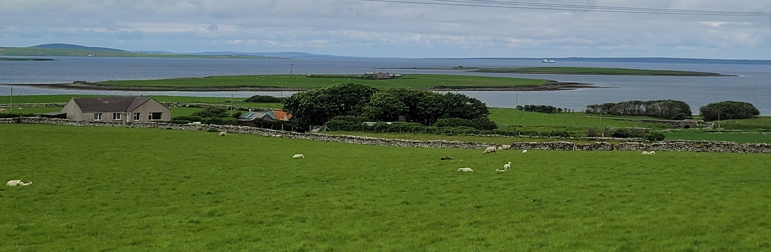
View of Damsay and Grimbister from Cursiter (Damsay is the furthest island).
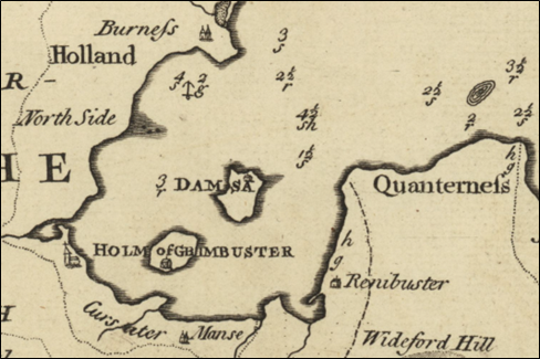
Detail from MacKenzie’s map of Orkney (1750), showing Damsay and the Holm of Grimbuster in the Bay of Firth. Reproduced with the permission of the National Library of Scotland.
The generic is ON ey ‘island’ and is found in many place-names across Orkney. The specific, the qualifying element, is harder to agree upon. Marwick (1923) tells us that ‘Professor Munch regarded this as a Celtic personal-name and suggested that it might have been named after St Adamnan (Adomnán). Marwick had little time for this proposal although it has remained persistent in local lore. Marwick instead proposed that if regarded together with the Holm of Grimbister a meaning of ‘twin islands’ was plausible as found elsewhere in the Norse speaking world. However, as with Stora and Litla Dimun in Faroe, dimun places are notable for their height. Thus the possibility for this being the case for Damsay (and Grimbister) recedes, these islands are flat even by Orkney standards notwithstanding that the name is applied to only one of the islands. Alternatively Sandnes (2010) proposes, while there is no documentary evidence, that a ‘Celtic personal-name is perhaps present, cf. modern names such as Daimine, Daman and Demmán’.
Joseph Ben, when describing Damsay in the second half of the sixteenth century, refers to disappearing supercilia, literally ‘eyebrows’, to describe a tidal shore feature. There is archaeological evidence of an undated, offshore fish trap running along the east coast of Damsay and since it is located in Aurriðafjǫrðr ‘Trout Firth’ (now Bay of Firth) this may be a plausible explanation for this eyebrow feature.

Example of a tidal fish trap. North Inch, Seamill, North Ayrshire. Creative Commons.
Additionally, there is a local tradition of a causeway and recent archaeological evidence of one between Damsay and Mainland across the shallow waters towards the Skerries of Coubister (roughly where ‘North Side’ is marked on the map above). Notably, the Holm of Grimbister is still linked by a tidal causeway, all of which may have given the area a ‘dam-like’ appearance.
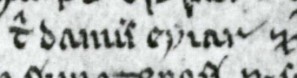
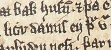
Manuscript 325, 18r l. 21, `t(il) dami`s eýiar`.
The tantalizing ‘dam’ interpretation, however, is not supported by the manuscript spellings, since the earliest forms should indicate spellings like damms or dammsins eýiar or, if referring to more than one dam, damma or dammanna eýiar. The earliest spelling (ca. 1290 – 1310) in manuscript 325 is,`t(il) dami`s eýiar` (the ‘`’ symbols represent the abbreviation marks in the manuscript). No ‘n’ is present here, although the abbreviation mark between the ‘i’ and the ‘s’ may indicate otherwise, or an ‘m’, to form either damins eýiar or dammis eýiar.
Flateyjarbók, 136vb l. 46, damís eý.
Flateyjarbók (1387–1394), contains the next earliest spelling with damis eý. This close examination of the earliest manuscript forms, however, does not get us any further. ‘Dam’ is dismissed and the meaning of the element remains elusive. The next earliest spellings for Damsay occur in a 1627 survey of the parish which has the modern-day spelling, followed by Blaeu’s 1654 map on which it occurs as ‘Dams Øy’.
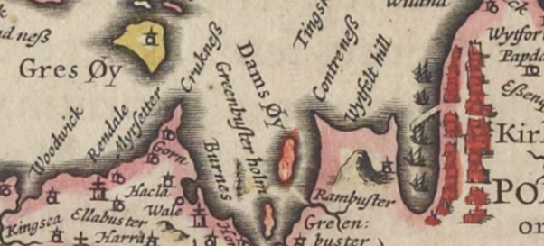
Detail from Blaeu’s map of Orkney, showing ‘Dams Øy’ and ‘Greenbuster holm’ (Grimibister), 1654. Reproduced with the permission of the National Library of Scotland.
In summary then, we have little certainty about the meaning of the place-name Damsay. We can with some degree of confidence rule out Marwick’s suggestion of the Celtic loan word Dimun. Likewise, a link with St. Adamnan seems unlikely, but Sandnes’s proposal that Damsay may contain an unknown Celtic personal name remains a possibility, especially since ‘dam-island’ is ruled out by the manuscript evidence. Having said that, the two seventeenth-century non-saga attestations above show how much the place-name evolved, and perhaps what we have here is a place-name that came to mean ‘dam-island’ once the original meaning of damnis/dammis/damins had been lost.
Corinna Rayner and Matthew Blake
Further reading
Bates, R.; Bates, M.; Dawson, S. Nayling, Nigel, & Wickham-Jones, C. R. The Rising Tide Report on Fieldwork June 2010 (University of St Andrews, 2010).
Blaeu, Joan, Orcadum et Schetlandiae Insularum accuratissima, 1654, https://maps.nls.uk/view/00000495. Reproduced with the permission of the National Library of Scotland.
Hunter, Margaret, ‘Jo Ben’s Description of Orkney’ New Orkney Antiquarian Journal, 6 (Kirkwall: 2012). pp. 34–47.
MacKenzie, Murdoch, Map of Pomona or Mainland (1750) https://maps.nls.uk/view/85449277 . Reproduced with the permission of the National Library of Scotland.
Marwick, Hugh, ‘Celtic Place-Names in Orkney’, Proceedings of the Orkney Antiquarian Society (Kirkwall: Orkney Antiquarian Society, 1923).
Sandnes, Berit, From Starafjall to Starling Hill: An investigation of the formation and development of Old Norse place-names in Orkney (Scottish Place-Name Society, 2010).
For information on the Damsay fish trap see https://canmore.org.uk/site/307261/damsay.
No comments yet, fill out a comment to be the first
Leave a Reply