May 3, 2020, by Kathryn Steenson
Dog Island
This is a guest post by Geography PhD student placement Robert Frost.
My placement started in October 2019 with the aim of looking at the Engineers’ Files of the water drainage records in the University’s Manuscripts and Special Collections (MSC). These covered the predecessor bodies of the Severn Trent Water Authority, including the Trent Catchment Board and the Trent River Authority. Both organisations were quangos (quasi-autonomous non-governmental organisations), which employed several hundred full-time staff, ranging from the manual workers to clerks and engineers.
My project was on the latter group, who had left boxes of correspondence, all of which ended up with the university in the 1970s. In a condition worse for wear, they were only roughly catalogued and incomplete (Sarah, one of the archivists I am working with, told me that entire sections, such as those related to water pollution, were missing).
Just by looking at the catalogue references, it is both easy and hard to appreciate the sheer extent of the water drainage records. At one level, the online catalogue has around 2,000 “items” for “RE/F/G&MW” (the Engineers’ Files) – obviously a very large number. On the other hand though, it’s unclear as to what precisely a “file” is. For the most part, the catalogue descriptions are so brief that they shed no light at all on the issue: are they single pieces of paper, envelopes, folders, boxes, or what?
Going behind the scenes into the store, an absolutely gigantic room crammed with huge metal bookcases the size of supermarket shelves but three times as high, I had a look at the water drainage records with Sarah. It was now easy to appreciate the huge extent of the water drainage records, which are stacked up and fill several lengths of these gigantic bookcases: many dozens of metres of shelving: it is no wonder the boxes are not so well catalogued. The question was where to begin as much as anything else. Sarah and I pulled out a box which was relatively easy to get to. Only labelled with a serial number, we had a look at the first document inside, “Purchase of Dog Island”. Intrigued as to where this place was and what else was in this box big enough to contain about ten laptops on it, it looked as good a place to start as any.
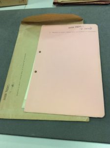
I spent a couple of sessions looking at the “Dog Island” box and improving MSC’s catalogue of it by noting the date, contents and any other information, such as on images if any were present, as well as general condition, on a spreadsheet, of each file in it (each inside its own envelope). As I progressed, I began to realise that the rather nondescript “water drainage records” title of these boxes didn’t convey the variety of material in there, nor its interest.
The first surprise was that like its larger namesake, the Isle of Dogs in London, Dog Island was not in fact an island. Rather, it was a 420-foot stretch of riverbank on the western (Nottinghamshire) side of the River Trent, opposite the north Lincolnshire town of Gainsborough. In any case, it was acquired by the newly-formed River Trent Catchment Board in 1934, on the advice of an unnamed engineer. The plan was to straighten the bank, to produce a wider river – presumably this was to improve the waterflow of the River Trent.
The most interesting file was titled simply “Complaint by Messrs. Pearson Bros., as a result of improvement”. Dating from 1935, it detailed a blow-by-blow account of a stakeholder conflict between a well-meaning river-management body and a local biscuit-manufacturer, which quickly escalated. It all started when Mr. A. W. Jones of Pearson Brothers (the biscuit manufacturer) politely conveyed concerns to the Trent engineers that the removal of “projecting points” in the river – it is uncertain whether these were the same ones that led to the initial purchase of Dog Island – could silt up his company’s berths on the River Trent. An annotation on the printed letter corrected “many tonnes” to “many thousands of tonnes” of produce. Back in the early 20th century, the River Trent was a vital industrial waterway. This was apparently in conflict with land drainage. The letter was met by a polite rebuff from the Trent engineers, explaining that the proposed change was “simply reverting to the original channel” and that the projections themselves “never ought to have been allowed”. All this is below a professional letterhead and list of the corresponding engineer’s qualifications. Implicit was a clear message: “We’re the experts, we know what we’re doing and we’re going to do it”.

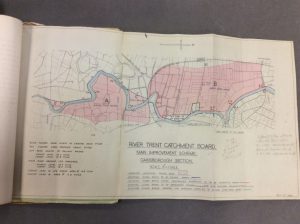
Map produced by the River Trent Catchment Board showing a proposed flood protection scheme for the River Trent at Gainsborough (1938).
The story could have stopped here, but Pearson Brothers were not to be outdone: if the River Trent Catchment Board wanted to claim expert knowledge, so could they. Rather than carrying on with their one-on-one correspondence, Pearson Brothers teamed up with eight other Gainsborough manufacturers and appointed their own professional hydrologist, to make their case against the Catchment Board. The rest of the files are fragmentary and frustratingly incomplete – they took place alongside phone calls and a “private chat”, but Pearson Brothers’ gambit may well have worked: there is no further correspondence over the issue. Subsequent files on Dog Island return to more mundane issues. It is entirely conceivable that the Catchment Board, under-resourced as Haile himself (the Engineer to the Board) often noted, stepped back and concentrated on other parts of the River Trent that needed attention.
Despite the events taking place more than 80 years ago, they strangely enough link in to a debate on how best to manage rivers that has echoed ever louder, every time Britain suffers major flooding. Just like in this case from the 1930s, far from wanting ever-greater intervention in rivers, fluvial scientists are increasingly set against “hard engineering” strategies, instead being in favour of letting natural processes do their work uninterrupted. River restoration, it seems, is back on the table after 80 years – but will it help? For those wanting to keep up with the debate, there is no longer any need for visiting Gainsborough, for there is a far more local example. South of Nottingham University Park, the Tottle Brook is set to be “re-naturalised”. Let’s hope we’re not in for Dog Island II.
No comments yet, fill out a comment to be the first


Leave a Reply