July 5, 2017, by lzzeb
Wonder 2017
A blog by the Geography Wonder team
Wonder 2017 was held on 17th June, the hottest day of the year so far. The sunshine brought everyone out and University Park was filled with interested and curious minds from all ages. Sir Clive Granger hosted Zone 5 and Geography were joined by other schools displaying everything from flight simulation to Tai Chi massage. The geography team had 3 activities; Jess Wardlaw was based in the café area with MarsCape, Gary Priestnall, Tom Stanton, Teresa Needham and Sue Davis were in the Geosciences Lab (which was thankfully air-conditioned) with CSI Geography.
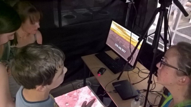
MarsCAPE is a model of the area on Mars that will be explored by the European Space Agency’s ExoMars mission, which is designed to engage the public with the aims of the mission and for comparing the environments on Earth and Mars. Situated opposite a very popular flight simulator, people were keen to find out why we had Mars in a Geography department. Memorably, one boy effortlessly explained why Mars has a thinner atmosphere than Earth! The atmosphere was also thin inside the MarsCAPE gazebo, where visitors were amazed to find it was much more than a 3D image and they could run their fingers over the craters. They were fascinated to find out what the different visualizations were showing, and what we can learn about Earth by exploring Mars. Further information about MarsCape can be found here: https://marscape.wordpress.com/
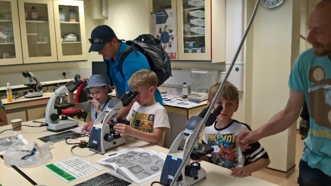
In the Geosciences Lab there were displays of maps from the 1600’s going forwards, diagrams of how soil samples are taken and explanations about the extraction of elements from samples using the ovens, and why geographers look at pollen grains and diatoms from fresh and salt water. We had both pollen grains and diatoms in different forms under the microscopes which from everyone found interesting. There were plenty of questions from all ages, including ‘were the diatoms alive’.
Another aspect of geographical reconstruction on display related to landscape models. Visitors could examine one of the negative moulds from Mayson’s model of the Lake District from 1875 and guess which part of the area it related to. The original model measured 4.5m by 5m but is believed to have been destroyed in the 1980s so geographers have been attempting to reconstruct it from the moulds and other evidence.
MarsCAPE in action at Wonder
With advances in 3D printing it is easier to create physical landscape models and one area of interest in the school is to develop displays where maps and images are projected down onto landscape models. An example was on display where people could watch animated routes through a model of the University campus and see pictures from along that route on a monitor. Other effects include modelling water flow across campus or simulating street lighting.
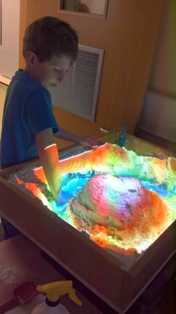
Another form of landscape modelling on display allowed visitors to attempt to recreate models of mountains or canyons in sand using contour maps as a guide. As they manipulated the landscape a new colour-coded relief map was projected down on to the model along with flowing water or lava. Whilst these displays are fun they may also have a role in teaching the public about the processes behind flooding especially when used alongside 3D printed models of real places.
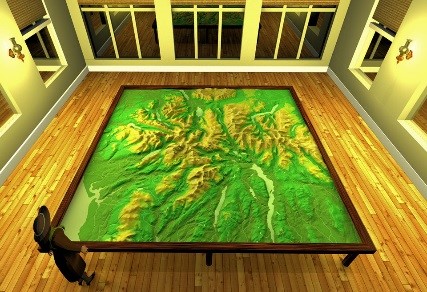
Mayson’s model of the Lake District
- It was estimated we had over 600 people walk through the lab doors and even if they just came to cool off they all interacted.
- Staff that attended as guests have remarked how good the atmosphere was this year in the room and in general.
- Kids enjoyed playing detective with the pollen grains and diatoms and trying to match them up with the diagrams, often battling with their siblings to get more correct than each other.
- Many primary school aged children had their first use of a microscope. One child now wants one for Christmas.
- Lots of secondary school children were taking Geography for GCSE and were very interested in what they were learning asking many questions about the topic but also university life.
- One lady spotted Long Row used to be called Rotten Row on an old map.
- People were interested when they realised that analysis of samples gives indications of previous climate changes.
- Some surprised faces when people were told how hot the ovens get and how measurements of samples are taken.
- We gave away over 250 geography pencils with many of the children saying they were taking them to school to show off.
Overall an incredibly successful day with lots of fun and learning.
Interactive Sandpit
No comments yet, fill out a comment to be the first


Leave a Reply