May 11, 2015, by Matt Davies
Digitising the Lake District: the Maysons project by DHC Volunteer alumnus Craig Goodere.
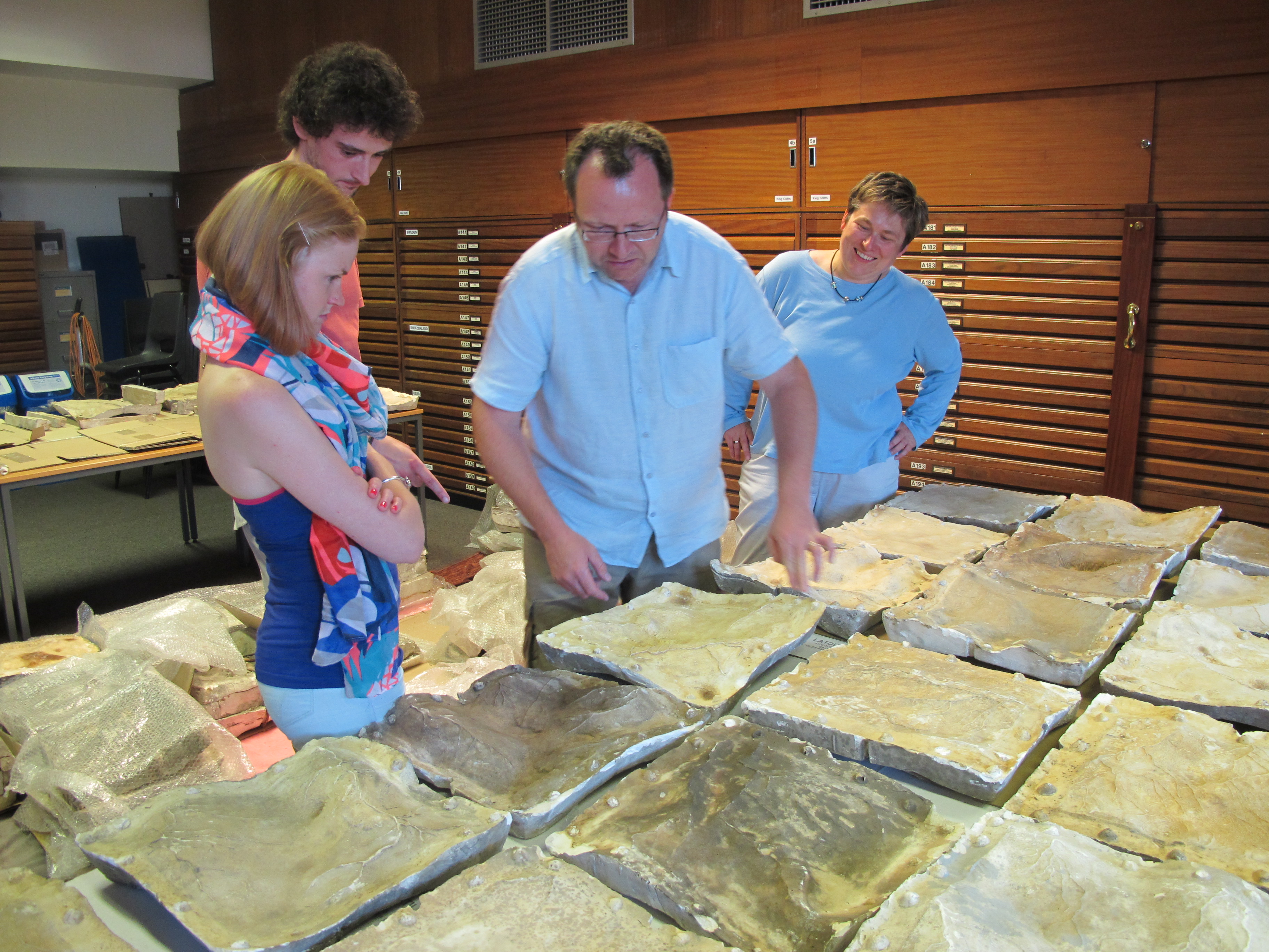
DHC Research Associates Robyn and Craig inspect a few of the 140 Victorian plaster moulds of the Lake District with Dr Gary Priestnell and DHC Director Dr Katharina Lorenz before 3D scanning begins, photo Matt Davies.
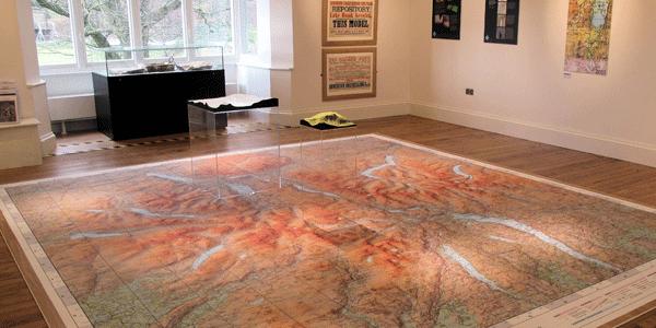
“The Grandest Views: Models of Lakeland from Victorian Times to the Present Day” exhibition is showing at the Keswick Museum and Art Gallery from Monday 9 February to Sunday 17 May. It is based on a research project led by Dr Gary Priestnall – a senior lecturer at the University of Nottingham’s School of Geography – to explore the first “mathematically accurate” 3D relief model of the English Lake District.
“Mayson’s Ordnance Model of the Lake District” was first revealed in 1875 and proved immediately popular with the Victorian tourists. However, by the early 1970’s, both the exhibition and its model had fallen into disrepair; their primary reason for being (of providing a bird’s eye view of the local topography) having been largely superseded by more convenient hand-held maps and guidebooks.
At its most basic level, Dr Priestnall’s project sought to conserve what remained of the model and recreate it (as far as possible) in digital form. To those ends, he approached Dr Katharina Lorenz of the Digital Humanities Centre (DHC) about the loan of the Centre’s Faro 3D high precision laser scanner.
As the DHC’s (then) Research Associates, Robyn Sullivan and I were tasked with scanning each of the model’s 140 surviving negative plaster moulds, from which a positive image could be created digitally.
Each mould is roughly one foot square and took 10 – 40 minutes to scan, depending upon the state of preservation. This was achieved by guiding the scanner’s “gun” across the surface of the moulds – in a criss-cross pattern – from a distance of about two inches. The data for each “run” was then recorded in real-time as laser “point clouds” on a laptop, checked for errors and finally passed to the School of Geography for further processing.
Although it sounds easy, it was actually anything but. Operating the scanner required a lot of physical effort and concentration (especially during the warm summer days); the Faro scanner is very sensitive to all sorts of vibrations – the slightest knock to either the scanner or object can completely change its point of focus (essentially: a set “coordinate” from which the subsequent 3D image is built upon) – and if there is no point on which to focus, the data cannot be captured accurately. Though annoying, this facet could also be extremely amusing at times; on one occasion, Dr Priestnall came to check our progress and made the mistake of making me jump during a scan… he did not come down to visit without forewarning us again!
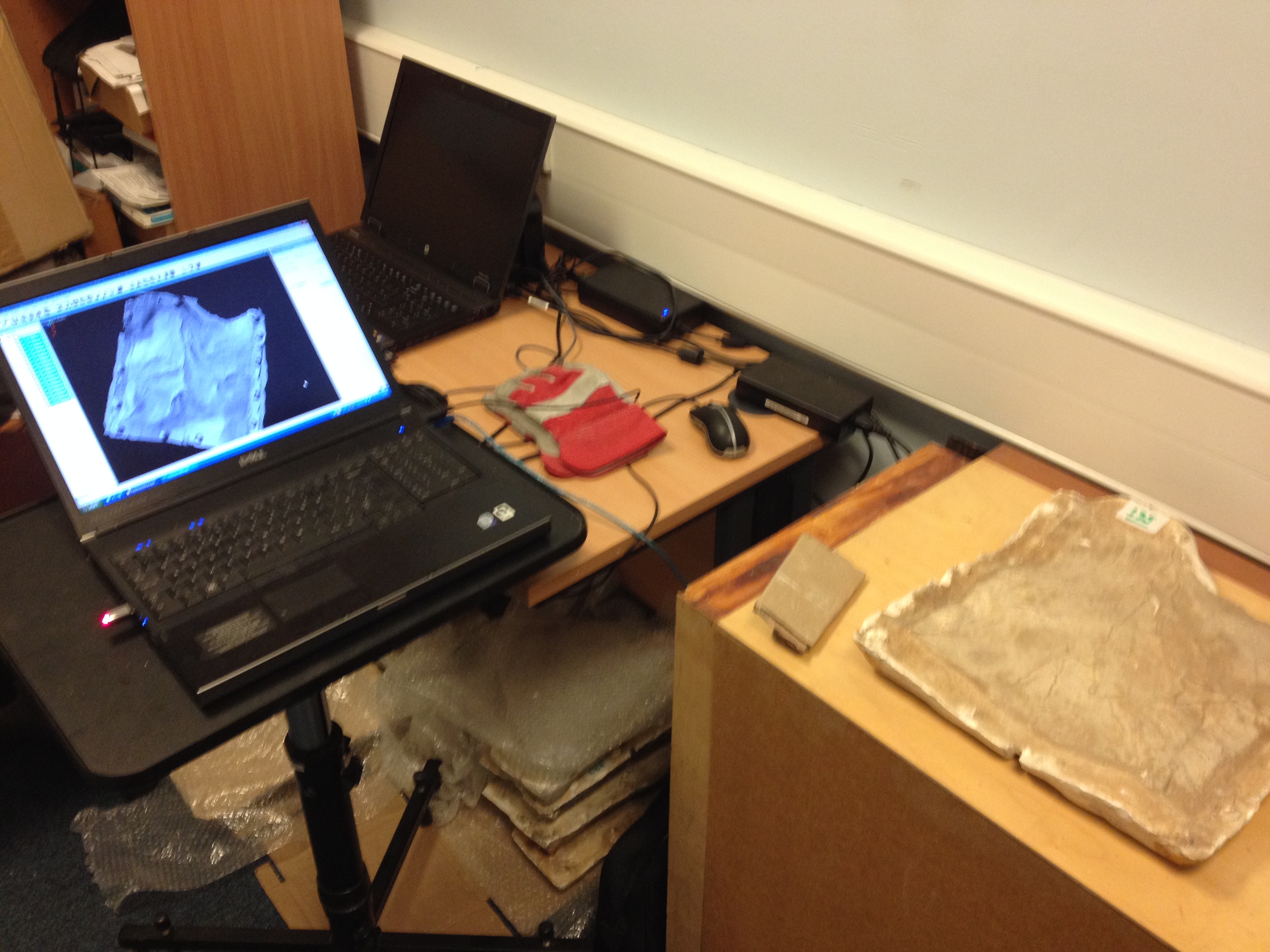
Work in progress: a laptop with the results of a scan, photo Craig Goodere.
Since it was highly impractical for one person to focus on scanning, while also checking the data on screen, we therefore decided to do the work as a team. One of us would concentrate on the actual scanning run, while the other would check the data as it appeared on the laptop for any problems, and then swap. When problems did occur, we either had to start that run again, or recalibrate the scanner (a time-consuming process that requires a lot of patience and skill) and then start again.
But perhaps our biggest problems were caused by the unusual state of the moulds themselves.
The moulds are made from a plaster like substance. Provided the surface was “clean”, they could be scanned relatively quickly; problems occurred when they had become damaged and/or developed a shiny surface layer due to years of being stored in poor conditions. Such cases were always problematic; the scanner’s laser simply could not “see” anything to capture. Such examples therefore had to be cleaned and/or coated in a thin layer of powder beforehand and, even then, could still take several attempts to scan efficiently.
Nevertheless, in spite of these hindrances and because we took the time and the care, when the scanning was finally completed the high standard of the results enabled the rest of the project to run smoothly .
For me and Robyn it proved a very good insight into the various aspects of working on a large scale, inter-departmental project at a university: inter-communications, deadlines, compromises, outside considerations were all tackled at one point or another. And of course, it was also an extremely interesting opportunity and project to be a part of, especially since we were kept in touch about the exhibition from start to finish – it’s not often that you get your hands on a piece of real history!
More information on the project and exhibition can be found here.
No comments yet, fill out a comment to be the first


Leave a Reply