October 13, 2020, by Blue-Green team
Merging Blue-Green infrastructure with urban design
Urban design with Blue-Green infrastructure plays a key role in addressing climate related water challenges such as water pollution, water scarcity, floods, land subsidence, stormwater management, ecosystem services and public health. Nanco Dolman (Royal HaskoningDHV) discusses this in greater detail.
Integrated water management
Integration of water management in the different phases of design and development is incredibly important in urban retrofit projects and new development.
Approaches such as water-sensitive urban design (WSUD) provide useful tools for strengthening the integration of water in spatial planning and urban design processes, requiring any spatial intervention or new development to be evaluated on opportunities for sustainability and innovation.
Nature-based solutions (NBS), sustainable drainage systems (SuDS) and blue-green infrastructure (BGI, e.g. urban wetlands, green roofs, swales, rain gardens, detention basins and ponds) are widely employed. These approaches enrich society through the provision of multiple co-benefits, including access to public greenspace, recreational opportunities, aesthetic enhancements, and improved management of environmental processes such as flooding, drought, urban heat and air pollution.
Just as infrastructure and the choice of development site are key factors in planning considerations, water management has a legitimate claim to be considered in this process. It is not just about open water and riverbanks: the choice of rainwater and wastewater systems also determine the required water storage facilities. Water is a connecting challenge in making cities resilient. Water then becomes a focal way of looking at cities and making them climate- and future-proof.
This makes it possible to move towards a balanced approach to treat precipitation close to where it lands through measures that deliver multiple benefits for water management alongside environmental and amenity benefits.
New and retrofit SuDS are being developed in appropriate places and integrated with programmes to deliver better and larger sewer systems. More projects are taking an urban design approach by building adaptively with water in mind and by investing in BGI. By strengthening BGI and giving water more space in both the public and private domain, the water city of the future has the potential to grow into a Blue-Green City.
Living with and making space for water
Solving the urban water assignment, or required storage capacity, is centred on ‘living with and making space for water’. This is both an engineering and design challenge. We must consider optional alternatives during the design process by linking the water assignment (e.g. required water storage) to BGI metrics (e.g. system and site scale measures). Figure 1 distinguishes the following four quadrants:
- Urban typologies – land use analysis in layers
- Water systems approach – cities as water catchments
- The urban water assignment
- Blue-green infrastructure – cities as ecosystem services providers
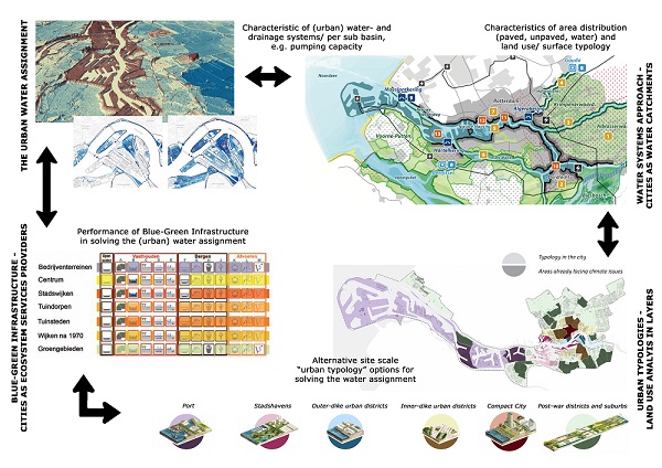
Figure 1. Linking the urban water assignment to Blue-Green infrastructure metrics
Urban typologies – the Dutch layers approach
In 1998, a stratified model that distinguished spatial planning tasks based on the differing spatial dynamics of substratum, networks and occupation patterns – i.e. three layers – was introduced in the national debate on spatial planning in the Netherlands. Although using layered models was not a new thing, this model hit a nerve in spatial planning practice, initially on a national level, but later also on provincial and municipal levels. Since 1998, this “layers model” has developed into an approach to spatial planning and design: the Dutch layers approach.
Water systems approach – cities as water catchments
One of the layers to spatial planning and design is the water system, both on the surface and sub-surface. Cities are part of, and have developed in, water catchments. Understanding both the urban and natural water system is vital when proposing and evaluating spatial interventions or new development. After the mid-19th century, towns and cities expanded to accommodate growth in industrial activity and population. Many waterways lost their infrastructure function and were filled in. During the 20th century the urbanisation pattern became linked to the new motorway network and water stopped contributing an organising role in urban development, whilst hydraulic engineering expertise made it possible to protect the land from flooding.
The urban water assignment
The water system analysis can be captured in a water balance or hydrological model. The starting point for the design of any urban water system is an overview of the functions the water system must fulfil, now and in a sustainable future. These functions and functionalities are the basis for the design standards that are to be applied. Such an overview of functions (or ecosystem services) should be composed for all five types of urban water (surface water, groundwater, rainwater, wastewater and drinking water), as well as for the urban soil and subsurface.
Storage and discharge are exchangeable. Stormwater runoff that we cannot discharge into the drainage system needs to be stored temporarily in the urban environment. We will have to discharge any runoff we do not have capacity to store. The required storage capacity (or water assignment) does not only depend on runoff intensity, but also on discharge capacity. As designers we want to understand the relationship between the required storage capacity and discharge capacity.
Runoff intensity and volume can also be reduced. Runoff intensity depends on the design and construction of the buildings, streets, gardens and other urban infrastructure. Normally storm water will drain quickly from roofs and streets to canals and ponds via the storm sewers; the delay will be no more than 5-15 minutes and runoff losses could be 10% or less. But if we could divert the storm water to an infiltration facility via urban groundwater – in many cases a subsurface drainage system – the delay would be hundreds or even a thousand times larger.
Blue-Green infrastructure – cities providing ecosystem services
The design solutions to solve the water assignment are elaborated in city planning and in urban vision (statement) projects as well as demonstration (pilot) projects. Some practical measures and optional alternatives, both at system and site scales, include: (re) use of water, surface drainage (delay), retention (streets, parks), infiltration (swales), green infrastructure, storage of surface water, and adaptive and flood-proof building.
Plenty of BGI elements exist to reduce runoff and create numerous alternative options for solving the storage design problem. These alternatives must be addressed during the design process by at least considering separately a fast surface and piped runoff component and a slow runoff component through the soil/subsurface drainage system. Incorporating these best practice guidelines or BGI elements in a manual would be the next step forward.
Justification
The contents of this blog have been adapted based on part of the chapter [2] on ‘Integration of water management and urban design for climate resilient cities’ in the forthcoming Palgrave Macmillan book on ‘Climate Resilient Urban Areas – Governance, design and development in coastal delta cities’.
No comments yet, fill out a comment to be the first

Leave a Reply