Pakistan, India and mapping the contested accession of South Asia’s princely states
October 3, 2019
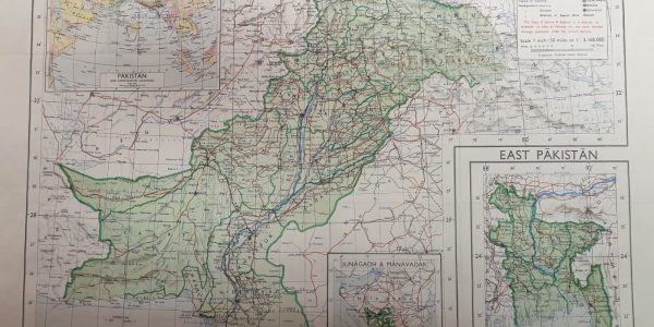
A blog by Philip Jagessar Earlier this year the government of India controversially revoked article 370 of the constitution which had given the long disputed state of Jammu and Kashmir a degree of autonomy from the rest of India. Pakistan loudly protested this unilateral move by India and rising tensions have revived fears of a …
Imagining Invasion: Stadtdurchfahrtpläne England (ohne London) 2. Verbesserte Auflage, 1941
August 6, 2019
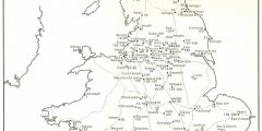
A blog by Dr Isla Forsyth The above map is the frontispiece to a booklet produced by the German military in the Second World War, which details the local geography of British city road maps, as well as the distances and directions for and between different cities and nearby towns. These military maps were produced …
Jeux avec frontières: a map of the historic borders of France prepared for the Paris Peace Conference in 1919
July 2, 2019
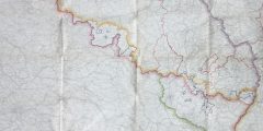
A blog by Professor Mike Heffernan While preparing for a recent visit to the School’s map collection by members of the Charles Close Society, an unusual map of north-eastern France was uncovered in drawer B109 in a miscellany of war-related material that includes a Napoleonic map of central Europe, several World War One trench maps, …
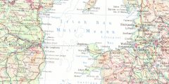
The Saint John River valley: memories of a submerged riverscape
June 5, 2019
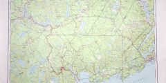
A blog by Dr Stephen Dugdale The School of Geography’s map collection contains a large number of historical maps of Canada. Two of these, sheets 21G and 21J of the National Topographic Series 1:250,000 collection (published between 1955 and 1959), are of particular interest. These maps, centred on Fredericton and Woodstock in the maritime province …
Karta Mira 35
May 2, 2019
A blog by Professor Mike Heffernan Drawers A2-A4 of the School’s Map Collection contain more than 260 map sheets of the Karta Mira, a cartographic project undertaken by geodetic agencies in the Soviet Union and the communist countries of central and eastern Europe at the height of the Cold War. Each of these 100 x …
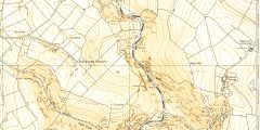
Spring flows in the River Dove
April 9, 2019
A blog by Dr Matt Johnson The 1:10 000 Ordnance Survey map sheet SK 15 SW shows the Derbyshire-Staffordshire border running through Dovedale. The version of the map shown here is from 1978; the sheet as a whole is centred on Ilam, extending from Milldale in the northeast to Calton in the southwest. Although this …
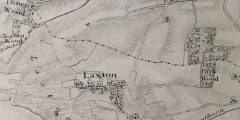
Map of the month. Map of the County of Nottinghamshire, George Sanderson, 1836
February 28, 2019
A blog by Professor Charles Watkins The surveyor George Sanderson, of Mansfield, was born in Richmond, Yorkshire in 1798 and took over the Mansfield firm in 1828. Like most early nineteenth century cartographers he was kept busy charting the many ways that Britain was being reconfigured and transformed. He surveyed and mapped enclosure awards, produced …
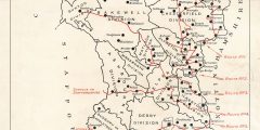
Refugees from Eastern Counties
January 22, 2019
A blog by Professor Matthew Smallman-Raynor This Great War map was prepared by the County Chief Constable’s Office, St. Mary’s Gate, Derby in January 1916. It depicts the planned routes of movement of ‘refugees’ from eastern England for the sanctuary of Derbyshire in the event of a hostile landing on the Lincolnshire coast. Eight planned …
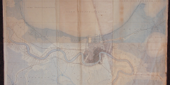
Mapping the Mississippi
November 28, 2018
A blog by Dr David Beckingham This map consists of six original individual survey sheets of Louisiana, each measuring 16½ by 20 inches. They are a product of the United States Geographical Survey’s desire to produce a topographical atlas of the country, which it began in 1882. Described as being of ‘average public importance’, the …