March 31, 2025, by lzzre
A year, a summer, a second: a dual perspective on glacial change
Libby Pattison, PhD student
I first visited Midtdalsbreen and Blåisen, two outlet glaciers of the plateau icefield Hardangerjøkulen in Norway and the field sites for my PhD, in September 2023. Since then, I’ve been back twice: once in July, and then again in September 2024. Forty-three days, spread across a single year. This has given me the unique opportunity to see the changes in these environments firsthand, and the change is profound.
The Hardangerjøkulen icefield is modelled to disappear completely by 2100. Such predictions are as stark as they are unsettling. The icefield is not a passive and dying relic of a cooler era, but an active part of the environment. Meltwater from the icefield provides drinking water, nourishes ecosystems, supplies rivers and lakes, and powers three hydroelectric power plants which produce around 3000 gigawatts of energy annually. Research is often framed in statistics like these, and for good reason. However, repeat visits to Hardangerjøkulen have offered a dual perspective- one shaped by my research findings, and the other by my personal experiences of these landscapes.
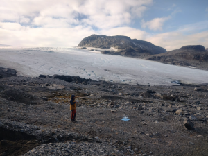
When I first saw the glaciers in September 2023, after a year of zooming in and back out of aerial imagery, the first thing that struck me was the sheer amount of sediment amassed and deposited in the glacier forelands. I suppose this observation is to be expected, since my PhD is focused on landforms and sediments formed at the outlet glaciers. The closer you get to the ice, the more the ground beneath your feet seems to belong to another planet. It reminded me of passage from Christiane Ritter’s introspective memoir of living on an Arctic island north of Norway for a year: “The stony land, the whole monstrous barrenness, clings to me like a bad dream.” For Ritter, the Arctic’s desolation was ominous, alien. For me, the raw landscape of Midtdalsbreen and Blåisen offered the chance to piece together their histories and potential futures.
A key part of my fieldwork involved collecting data from the sediments (“dirt”) within moraines – ridges of debris deposited at and around the margins of glaciers. The “dirt” inside glacial landforms, such as moraines, contains distinctive features that can tell us how the landforms were formed, where they were deposited, and how the glacier was behaving at the time. This information is particularly important if we want to understand how these outlet glaciers are responding to current climate change – knowledge that can help us understand glacier systems and improve predictions of future change.
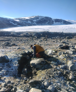
Kneeling in the sediment in front of one of these moraines, a small plastering trowel in hand, I saw – or rather heard – my first sign of change.

Investigating the sediment inside a moraine at Midtdalsbreen. Photo credit: Sarah Dyson- my wonderful field assistant.
A second.
A crack that echoed off the bedrock walls and a small wave of water which nearly reached my boots. The tell-tale signs of a small chunk of ice calving off the front of the glacier into the small but growing proglacial lake. It was a reminder that the ice is not as impassive and immovable as it sometimes seems. These small melt and calving events in the summer months are not uncommon. The glaciers undergo summer melt and small winter advance cycles, but the expansion of proglacial lakes is a telltale sign of glacial retreat. By using aerial photos dating back to the 1960s and mapping meltwater pathways at Midtdalsbreen, we’ve been able to track these changes. Over the last 60 years, the glacier has retreated down into a hollow and water is now pooling in a growing proglacial lake. This shift in glacial hydrology is likely to have cascading effects on the glacier system and its behaviour.
A summer.
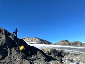
A key part of my fieldwork, alongside looking at the dirt inside moraines, was conducting drone surveys of the two glaciers and the landscapes emerging at their margins. Our aim was to use drones to capture repeat photos at the start and end of the summer melt season, so we could see how much the landscape had changed around the glacier margins. Using these photos, we can use a processing technique called Structure-from-Motion photogrammetry to create 3D models of the landscape. Where you have two of these 3D models, you can subtract them from each other to calculate how much the glacier and surrounding landscape has changed.
It was a season of transformation, seen not only through numbers but also through the landscape’s evolving terrain. Early in the summer, we discovered an exposed block of glacier ice that had separated from the active glacier and been buried by glacier dirt (layers of sands and gravels). The sands and gravels were partly protecting the buried ice from melting – exposed ice melts much faster. However, when I returned in September, the ice had vanished entirely, and the once-distinctive exposure was nearly unrecognisable. Only the GPS alone could confirm that it was the same spot. For me, this moment underscored the transient nature of these features, emphasising the need to document them.
A year.
My first visit to Hardangerjøkulen in 2023 was one of reconnaissance – I was checking my mapping and locating sites for further investigation. When I returned the following year, armed with a notebook full of quick sketches, GPS co-ordinates, and photographs, I found that the once familiar ice-marginal landscape had reconfigured itself dramatically. Meltwater channels had shifted, the ice had retreated and reshaped itself, and some of my sites earmarked for sedimentary investigation no longer existed.
It is one thing to study predictions and see changes in imagery; it is quite another to stand in the front of these glaciers and be able to see these changes within just one year.
I hope that we can establish a repeat surveying programme at Hardangerjøkulen so that we can continue to assess the glaciers, and how their landscapes are changing in response to climate warming. Witnessing the retreat firsthand, I’m left wondering what these glaciers will create and uncover as they recede into the mountains and onto the plateau, and what research and questions we might be able to answer as they do.
No comments yet, fill out a comment to be the first


Leave a Reply