Anticipating Genocide: An Ethnographic Map of Central Europe in 1942
April 10, 2024
A blog written by Professor Mike Heffernan The School’s map collection includes many items from World War Two, evidence of the close relationship between cartography and war. One of the more eye-catching examples is a large, 1:1 million ‘Ethnographical Map of Central Europe’, printed in Budapest in 1942 with title and accompanying text in English. …
Lauge Koch and the Colonial Mapping of Northern Greenland
February 13, 2024
A blog by Dr Peter Martin Like nearly all substantial map collections, the School of Geography holds a range of maps that depict and represent colonial and postcolonial spaces around the world. Of relevance to my own research interests, this includes a number of maps centred on those areas of the Arctic that have historically …
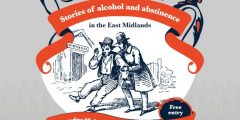
Last Orders: Pubs and maps
August 2, 2022
A blog by Dr David Beckingham I am the co-curator of an exhibition called Last Orders: Stories of Alcohol and Abstinence in the East Midlands, on display at the Weston Gallery at Lakeside Arts until October. The exhibition examines a series of tensions that gathered around drink in the two centuries before the First World …
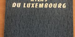
Parsing the Duchy: Nottingham and the Mapping of Luxembourg
July 19, 2022
The Atlas du Luxembourg. A blog by Professor Mike Heffernan The School of Geography’s map collection includes several items that highlight a forgotten association between Nottingham geographers and the Grand Duchy of Luxembourg. K. C. Edwards (1904-1982), the University’s first Professor of Geography, had a life-long interest in this tiny, land-locked European state. Towards the …
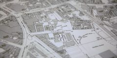
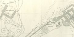
Broad Marsh before The Broadmarsh
June 1, 2021
A blog by David Beckingham. Sitting between the railway station and the central areas of the city, the site of Nottingham’s former Broadmarsh Shopping Centre is a large and strategic one. The COVID-19 pandemic and the collapse of the centre’s operator intu forced the abandonment of approved redevelopment plans before they could be completed. There …
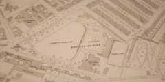
Locating the Nottingham General Asylum
May 5, 2021
In this special blog, David Beckingham uses maps from the School of Geography and University of Nottingham’s Manuscripts and Special Collections to trace the site of Nottingham’s General Lunatic Asylum in Sneinton, now King Edward Park. It is a version of a talk David gave at an event earlier in the year to mark the …
The School of Geography Map Collection goes online
January 12, 2021
Are you a student or staff member or somebody who just loves maps? Maps in the School of Geography’s extensive collection are now searchable via the University’s library discovery tool, NUsearch. About the collection The School of Geography map collection is the main cartographic holding within the University and one of the largest in the East Midlands, comprising over 85,000 paper …

Workplace Views
May 12, 2020
A blog by David Matless May 2020. The School of Geography, and its map collection, are locked down. The ‘Map of the Month’ blog is out to grass for now, but another element of the School collections has recently been restored to view, and provides the occasion for this piece. Within the School’s archive room …
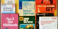
Motoring maps
February 18, 2020
A blog by David Beckingham The School map collection is primarily organised by country, with drawers then differentiated according to scale and only comparatively rarely by distinctive category. However particular types of map can be found right across the collection, and there are occasional groupings of specialist maps. The collection contains many different travel and …
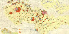
Mapping Industry in the Czechoslovak Socialist Republic
December 5, 2019
A blog by Dr Andy Cook In November 2019, the former Czechoslovakia commemorated the 30th Anniversary of what became known as the ‘Velvet Revolution’ – a series of largely peaceful protests that heralded the end of four decades of state socialist rule in the country. Given the significance of this anniversary, it proves useful to …