March 10, 2016, by Blue-Green team
Outputs from the Blue-Green Cities Research Project (Feb 2013-2016)
The Blue-Green Cities (EPSRC EP/K013661) research team have spent the last three years creating methodologies and frameworks, conducting field and lab work, testing novel techniques, and developing models to evaluate the multiple flood risk benefits of Blue-Green Cities. A Blue-Green City aims to recreate a naturally-oriented water cycle while contributing to the amenity of the city by bringing water management and green infrastructure together. A key output is the development of a GIS Multiple Benefits Toolbox (free to download from the Blue-Green Cities website) that can help practitioners understand the relevant dominant benefits, and spatial distribution of benefits, for SuDS/Blue-Green infrastructure schemes. This complements existing monetisation techniques. Research is described in a series of factsheets and a Key Project Outputs summary.
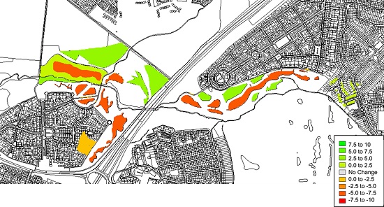
Multiple Benefit Evaluation of SuDS in Newcastle Great Park.
Other research outputs include;
Uncertainty: A new framework has been created to characterise the uncertainties and barriers to widespread implementation of Blue-Green infrastructure; in our Portland case study, the socio-political uncertainties, including public preferences and political will to champion Blue-Green approaches, exerted a much stronger influence on decision making when compared with the biophysical uncertainties (e.g. modelling, future maintenance and service delivery). See Thorne et al., 2015.
Communications: A Learning and Action Alliance (LAA) has been established in Newcastle to bring together professional stakeholders to create a joint understanding of flood and water management problems and negotiate possible solutions. The LAA has opened communication channels with those not typically involved in flood and water management, strengthened existing relationships and created opportunities for collaborative working to achieve common goals and potential for joint funding.
Flood inundation modelling: the CityCAT hydrodynamic model has been developed to better represent pluvial flood inundation in urban areas. The model can also fully couple the surface flow with flow in the storm sewer network, for the first time linking gullies/drains and sewer pipes, and model the movement of water through Blue-Green features (e.g. blue-green roofs, retention ponds, permeable paving, swales, water butts), demonstrating that Blue-Green infrastructure can reduce local and downstream flood risk.
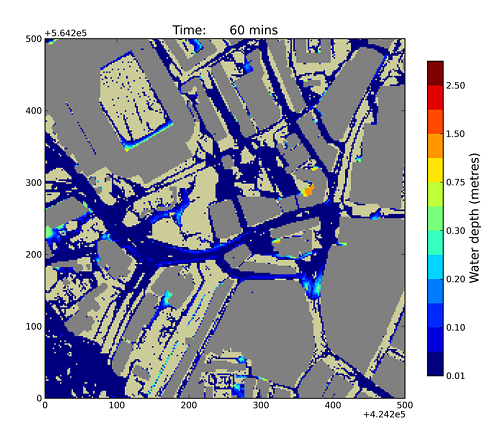
Flood inundation modelling output from CityCAT (Newcastle urban core)
Sediment transport modelling: a 2D hydro-morphodynamic model has been developed to predict flow and suspended sediment dynamics in urban rivers and investigate how restored floodplains and SuDS ponds can attenuate the upstream flood peak, act as a sediment sink and impact on downstream sediment transport.
Sediment, debris and ecosystems: detailed understanding of how Blue-Green infrastructure treats fine sediment and key urban pollutants during multiple rainfall-runoff events has been developed, and finds that Blue-Green assets and SuDS provide sediment detention, but not necessarily in the way, or to the level, that existing manuals suggest. Research has also determined the quantity of fine sediment being temporarily deposited within SuDS assets and identified the ecosystem service benefits provided. See Allen et al., 2015.
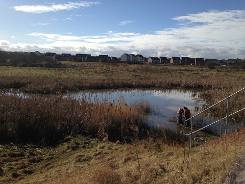
Sediment sampling in the Newcastle Great Park SuDS ponds
Behavioural responses of publics: analyses of questionnaires and interviews with communities have led to increased understanding of people’s perceptions of Blue-Green infrastructure and have identified key benefits (aesthetics, amenity, health and wellbeing). Members of the public value having a voice yet there is a general lack of understanding of wider Blue-Green infrastructure functions and service requirements. See Everett et al., 2015.
Flood Footprint: A flood footprint damage accounting framework has been developed to measure the total socio-economic impact that is directly and indirectly caused by a flood event. This can be used to optimise investment in Blue-Green infrastructure by identifying the blind- spots in critical infrastructure and vulnerable sectors in economic supply chains and social networks.
Systems of Systems: A series of interdependencies between stormwater management components and the wider urban landscape are defined, including physical, cyber, geographical and logical interdependencies. The effects of these interdependencies on the performance of SuDS and Blue-Green infrastructure, and how SuDS/Blue-Green infrastructure might impact on other aspects of the urban environment, have been identified. A green roof case study is used to demonstrate relational and organisational complexity and the range of benefits that can accrue. See Hoang & Fenner, 2015.
Newcastle case study: the team transferred their research to Newcastle in 2015 to evaluate the multiple benefits (environmental, ecological, social and economic) of a) the Newcastle Great Park SuDS ponds, and b) a hypothetical scenario incorporating Blue-Green infrastructure in the urban core and Wingrove ward. The research findings were presented at a Newcastle dissemination event: Improving Flood Resilience: The Blue-Green Advantage. The presentations are available to download on the project website.
Blog post by Emily O’Donnell (University of Nottingham)
No comments yet, fill out a comment to be the first
Leave a Reply